1. The Indus (Sindhu)
The Indus is one of the most important drainage systems of the subcontinent of India. It has a length of 2880 km, of which 709 km lies in India. The catchment area of the Indus is about 1,165,000 sq km, out of which about 321,284 sq km is in India.
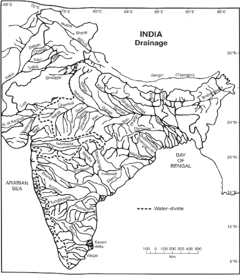
The Indus is the westernmost river system in the Subcontinent. Jhelum, Chenab, Ravi, Beas, and Satluj are its main tributaries. The Indus originates from the Bokhar Chu (glacier) in northern slopes of Mt. Kailash (6714 m). It drains the largest number of glaciers and mountain slopes of the Karakoram,

Fig. 3.6 River Systems of India
Ladakh, Zaskar, and Himalayan Ranges. Originating from the Kailash Mountain, it flows in a constricted valley north-westwards through Tibet (China), where it is called as Singi Khamban or Lion’s mouth. In Ladakh, it follows a long, nearly straight course between the Ladakh Range and the Zaskar Range. In the first 180 kilometres, it flows along the northern flank of the Zaskar Range over a flat country at heights over 3200 metres where it receives river Zaskar below Leh. Sum and Dras are the other left bank tributaries which join the Indus near Kargil. Moving north-westward, the Indus is joined by the Shyok-Nubra tributaries. These tributaries arise from the Siachin Glacier (Karakoram Range). At Skardu, at a little distance below the Shyok, the Shigar river, which drains the northern slopes of
Mt. K2, meets river Indus. In this region, River Indus is more wide than in Ladakh. The transverse glaciers and landslides periodically dam the river. The Gilgit is another important tributary which comes from the west to join Indus. Downwards, the Indus crosses the Central Himalayan Range through a huge synclinal gorge. The Indus makes saveral deep gorges. The deepest of all is at Gilgit, which is 5200 m in height above the level of the water at its bed. The river passes by the Nanga-Parbat and turns south-west to enter Pakistan.
