4.9. Upper Air Circulation
It is now realized that the causes of weather on the ground are intricately bound up with what happens at higher levels in the atmosphere. This applies especially to the development of anti- cyclones and depressions and to the general circulation of winds around the globe. Such phenomena can only be appreciated by understanding air circulation in the upper layers. Broadly speaking, wind speed tend to increase with altitude because of lower air density, lower frictional force etc. Direction of wind also is not same. For instance, during the month of July, surface wind(monsoonal) blow from south-west direction in India while at the height of 10km there are swift winds blowing from east to west.
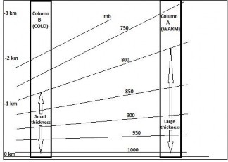
On a global scale, pressure patterns higher up tend to be much simpler than those at the surface level, largely because of the diminished thermal and mechanical effects of land masses. There is a falling pressure gradient from the sub-tropical areas towards the poles. The gradient is strongest in winter, when the temperature contrasts between the respective polar areas and the equator are most marked.