
Fig: Development of a meander.
In the middle course the volume of water increases with the confluence of many tributaries and this increases the river’s load. Thus work of the river is predominantly transportation with some deposition. Rivers which sweep down from steep mountain valleys to a comparatively level land drop their-loads of coarse sand and gravels as there is sudden decrease in velocity.
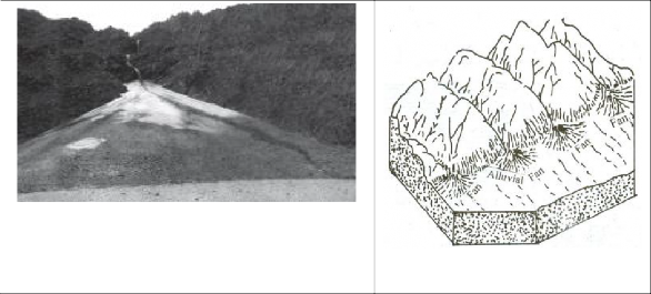
Figure 7.4: An alluvial fan deposited by a hill stream on the way to Amarnath, Jammu and Kashmir
The load deposited generally assumes a fan like shape, hence it is called an alluvial fan. Sometimes several fans made by neighbouring streams often unite to form a continuous plain known as a piedmont alluvial plain, so called because it lies at the foot of the mountain.
7.1.3.1.3. The Lower Course
In the lower course, the river moving downstream across a broad, level plain is heavy with debris brought down from the upper and middle courses. Vertical corrasion has almost ceased, the lateral corrasion still goes on to erode its banks further. The work of the river is mainly deposition in the lower course.
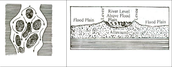
Diagram showing Braided stream
Many tributaries join the river and the volume of water increases, coarse materials are dropped and the fine silt is carried down towards the mouth of the river. Large sheets of material are deposited on the level bed and the river splits into a maze of channels. Such a stream is called a braided stream.
In lower course large quantity of sediment is carried by river. During annual floods, these sediments are spread over the low lying adjacent areas. A layer of sediments is thus deposited during each flood gradually building up a fertile flood plain.
A raised ridge of coarse material is also formed along each bank of the river due to deposition. Such ridges are called levees. They are high nearer the banks and slope gently away from the river. When rivers shift laterally, a series of natural levees can form.
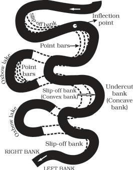
Point bars are also known as meander bars. They are found on the convex side of meanders of large rivers and are sediments deposited in a linear fashion by flowing waters along the bank. They are almost uniform in profile and in width and contain mixed sizes of sediments. Rivers build a series of them depending upon the water flow and supply of sediment. As the rivers build the point bars on the convex side, the bank on the concave side will erode actively and these zones are referred as cut bank.
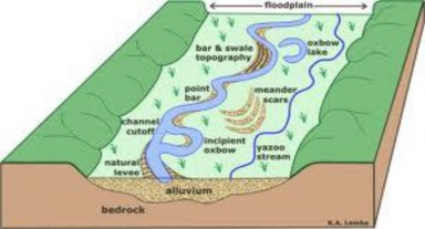
In the lower course of the river, meanders become much more pronounced. The outer bank or concave bank is so rapidly eroded that the meander becomes almost a complete circle. A time
comes when the river cuts through the narrow neck of the loop. The meander, now cut off from the main stream, takes the form of an oxbow lake. When the curvature of the meander loops is so accentuated due to lateral erosion, the meander loop become almost circular and the two ends of meander loops come closer, consequently, the streams straightness their coarses and meander loops are abandoned to form ox-bow lakes. This lake gradually, turning into swamps disappears in course of time. Numerous such partially or fully filled oxbow lakes are marked at short distance from the present course of river like the Ganga.
Upon entering a lake or a sea, the river deposits all the load at its mouth giving rise to the formation of a delta .Delta is a triangular relief features with its apex pointing up stream and is marked as a fan-shaped area of fine alluvium. Some deltas are extremely large. The Ganga- Brahmaputra Delta is the largest delta in the world. The following conditions favour the formation of deltas:
1. active vertical and lateral erosion in the upper course of the river to supply large amount of sediments,
2. tideless, sheltered coast;
3. shallow sea, adjoining the delta and
4. no strong current at the river mouth which may wash away the sediments.
Due to the obstruction caused by the deposited alluvium, the river discharge its water through several channels which are called distributaries. Some rivers emptying into sea have no deltas but instead they have the shape of a gradually widening mouth cutting deep inland. Such a mouth is called estuary.
The formation of estuaries is due to the scouring action of tides and currents. But in most of the cases the original cause is the subsidence of the earth’s crust in the area of the outlet. The two west flowing rivers of India, the Narmada and the Tapi do not form deltas. They form estuaries when they join the Arabian Sea.