7.1.3. Deposition
When the stream comes down from hills to plain area, its slope becomes gentle. This reduces the energy of the stream. The decrease in energy hampers transportation; as a result part of its load starts settling down. This activity is known as deposition. The larger particles, such as boulders and pebbles, are deposited first and the finest particles of silt are the last to be deposited. Deposition takes place usually in plains and low lying areas. When the river joins a lake or sea, the whole of its load is deposited.
7.1.3.1. Development of a River Valley
The erosional and depositional land features produced and modified by the action of running water may be better understood if we note the stages through which a stream passes from its source to its mouth. The source of a river may lie in a mountainous region and the mouth may meet the sea or lake. The whole path followed by a river is called its course or its valley.
The course of a river is divided into three sections:
1. The upper course or the stage of youth
2. The middle course or the stage of maturity
3. The lower course or the stage of old age.
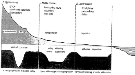
The Upper, Middle and Lower Courses of River
7.1.3.1.1. The Upper Course
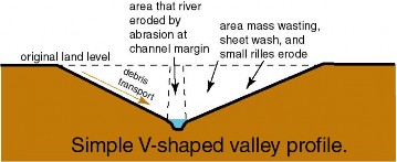
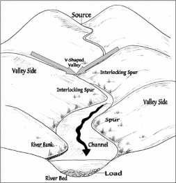
The upper course begins from source of the river in hilly or mountainous areas. The river tumbles down the steep slopes and as a result, its velocity and eroding power are at their maximum. Consequently, valley deepening assumes its greatest importance at this stage. Normally, weathering also plays its part on the new surfaces exposed along the banks of the stream. The weathered rock material is carried into the stream partly through the action of gravity and partly by rain water flowing into the river. Weathering helps in widening a valley at the top giving it a typical ‘V’ shaped cross section. Such valleys are known as ‘V’ shaped valleys.
♤ If the bed rock is hard and resistant, the widening of the valley at its top may not take place and the down cutting process of a vigorous river may lead to the formation of a gorge i.e. a river valley with almost vertical sides. George generally develops between pairs of escarpments or cliffs. In India, deep gorges have been cut by the Brahmaputra and the Indus in the Himalayas. Deep gorges also develop in limestone regions and in rocks lying in dry climates.
The Valley of Kaveri river near Hogenekal, Dharmapuri district, Tamilnadu in the form of gorge | Grand Canyon of the river Colorado in U.S.A. | |
interlocking spurs |
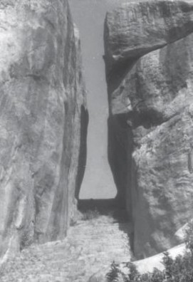
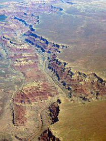
♤ The narrow and very deep gorge with vertical walls is known as ‘I’ shaped valley or canyon. A canyon is very deep gorge with steep sides running for hundreds of kilometers, e.g. Grand Canyon of the river Colorado in U.S.A.
♤ As the river flows through the valley it is forced to swing from side to side around more resistant rock outcrops (spurs). As there is little energy for lateral erosion, the river continues to cut down vertically flowing between spurs of higher land creating interlocking spurs.
Some of the others features that are developed in the upper course of a river include rapids, cataracts, cascades, waterfalls, potholes and plunge-pool.
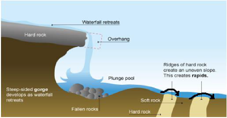
7.1.3.1.1.1. Waterfalls, Rapids and cataracts
Waterfalls develop when a layer of erosion-resistant rock lies across a streams course. The less resistant rock on the downstream side is more easily eroded than the resistant rock. The river bed is thus steepened where the two rocks meet and a waterfall develops. The great force of falling water in a waterfall makes hydraulic action effective at its base. The blocks of rocks are broken into smaller boulders by attrition as they collide against each other. The base is further eroded by abrasion to create deep plunge pools beneath.
Rapids are formed due to unequal resistance of hard and soft rocks traversed by a river, the outcrop of a band of hard rock may cause a river to 'jump' or 'fall' downstream. Similar falls of greater dimensions are also referred to as cataracts. These interrupt smooth navigation.
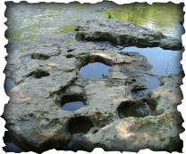
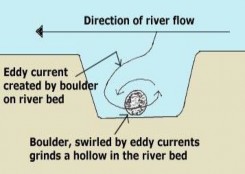
7.1.3.1.1.2. Pot Holes
River potholes can be created when larger pieces of load that the river cannot remove by traction are swirled around by eddy currents. An eddy current is where the water turns round on itself. The river is not strong enough here to pull the large boulder (as in the diagram,) the obstruction creates a swirling motion in the water. Eventually, the boulder creates a pothole, by abrasion on the river bed.
7.1.3.1.2. The Middle Course
In the middle course, lateral corrasion tends to replace vertical corrasion. Active erosion of the
banks widens the ‘V’ shaped valley and result in formation of 'U' shaped valley.
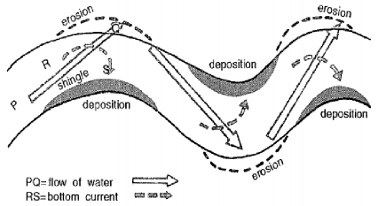
In middle valley course river often develops a winding course. Even a minor obstacles force a river to swing in loops to go round the obstacles. These loops are called meanders. Meander is not a landform but is only a type of channel pattern. The formation of meanders is due to both deposition and erosion and meanders gradually migrate downstream. The force of the water erodes and undercuts the river bank on the outside of the bend where water flow has most energy due to decreased friction. On the inside of the bend, where the river flow is slower, material is deposited, as there is more friction. Thus river Meanders refer to the bends of longitudinal courses of the rivers.