
RIVER REGIMES
The pattern of the seasonal flow of water in a river is called its regime. The main difference in the flow pattern of the Himalayan and the Peninsular rivers is caused by the differences in climate. The Himalayan rivers are perennial and their regimes are dependent on the pattern of water supply both from snow-melt and rainfall. Their regimes are monsoonal as well as glacial. The regime of most of the peninsular rivers, on the other hand, are only monsoonal as they are controlled by rainfall alone. Even regimes of different peninsular rivers are not the same because of the differences in the seasonal distribution of rainfall in various parts of the plateau (Fig. 3.10)
The discharge is the volume of water flowing in a river measured over time. It is measured either in cusecs (cubic feet per second) or cumecs (cubic metres per second). The Ganga has its minimum flow during the period of January to June. The maximum flow of water in the Ganga occurs either in July or August. After September, there is a steady fall in the flow of Ganga. The river thus has a typical monsoonal regime. There are striking differences in the river regimes in the eastern and western parts of the Ganga basin. The Ganga maintains a sizable flow in the early parts of summer before the monsoon rains begin. This is largely due to the water supply from the Himalayan snow-melt. The discharge data, however, do not include the volume of water diverted for irrigational purposes at different points before the Farakka Barrage (Maida, West Bengal). The mean maximum discharge of the Ganga at Farakka is about 55,000 cusecs, while the mean minimum is only 1300 cusecs.
The two peninsular rivers display an interesting difference in their regime as compared to the Himalayan rivers. The Narmada has a very low volume of discharge from January to July. It suddenly rises in August when the maximum discharge is attained. The fall in October is as spectacular as the rise in August. The Godavari flows at a low level until May. It has the minimum discharge in
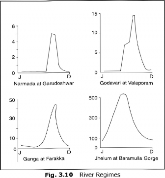
May and the maximum in July-August. After August there is a sharp fall in water flow, although the volume of flow in October and November is higher than that in any of the months fromjanuary to May. The mean maximum discharge of Godavari at Valaporam is 3200 cusecs. These figures give an idea of the regime of the river. The flow of water in the Narmada, as recorded at Gurudeshwar, shows that the maximum flow is of the order of 2300 cusecs, while minimum flow is only 1,5 cusecs.
The data on water discharge in different rivers in different parts of the year have important implications to their utilization by states. It is on this count that inter- state disputes arise.
Table 3.2 Major Rivers of Peninsular India
River | Source | Length in km | Main tributaries | |
1. | Godavari | Trimbak Plateau Near Nasik (Maharashtra) | 1465 | Manjra, Penganga, Wardha Wainganga, Indravati, Sabari, Pranhita |
2. | Krishna | Near Mahabaleshwar (Maharashtra) | 1400 | Koyna, Ghataprabha, Malprabha, Bhima, Tungbhadra, Musi, Muneru |
3. | Narmada | Amarkantak | 1310 | Hiran, Orsang, Barna, Kolar, Burhnar, Tawa, Kundi |
(Contd.)
(Contd.)
4. Mahanadi | Dandakaranya Plateau near Raipur | 857 | lb, Mand, Hasdeo, Seonath, Ong, Jonk, Tel |
5. Kaveri | Taal Kaveri | 800 | Herangi, Hemavati, Lokpavni, Shimsa, Arkavati, Kabani,Bhavani, Amravathi |
6. Tapi | Multai in Betul Distt. (M.P.) | 730 | Purna, Betul, Patki, Ganjal, Dhatranj, Bokad, Amravati - |