2. The Ganga Basin (length 2510 km; area 861,404 sq km)
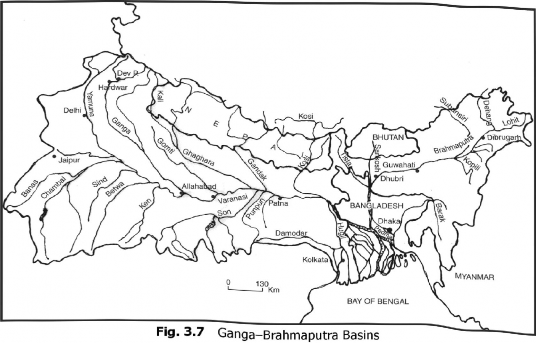
The Ganga basin is the largest river basin in India. It drains about one-fourth of the total area of the country. It is an international river as it passes through Bangladesh before merging into the Bay of Bengal (Fig. 3.7).

The Ganga is the most important river of India. In the opinion of Nehru, “From her source to the sea, from old times to new, the Ganga is the story of India’s Civilisation.” In fact, the Ganga is virtually synonymous with Indian Civilisation. Beyond water’s material uses, which are critical to life and development, Ganga water is associated with fertility, purity, and spiritual nourishment of the people.
The Ganga rises from the Gomukh Glacier (about 7000 m) near Mana Pass in Uttar Kashi District of Uttarakhand. This river is known as Bhagirathi, which cuts through the Greater Himalayas and the Lesser Himalayas in narrow gorges. At Devprayag, the Bhagirathi river meets Alaknanda river which has its source (7800 m) in the Satopanth Glacier to the north of Badrinath near Niti Pass. After the confluence of the Bhagirathi and Alaknanda at Devprayag, the river is called Ganga. Passing by Rishikesh, the Ganga debouches into the plains at Hardwar. From Hardwar, it turns towards the south-east upto Mirzapur in the Upper Gangetic Plains, and further down eastwards, in Bihar in the Middle Gangetic Plains. Near the Rajmahal Hills, it turns to the southeast below Farakka Barrage in Maida District of West Bengal. After the barrage, the river splits into two branches

namely, the Bhagjrathi-1 lugli and the Padma. The Hugli flows through Kolkata, while the Padma enters Bangladesh. At present, the Hugli is the westernmost distributary in the Bengal delta. The Hugh is a tidal river on which Kolkata port is situated. Further 121 km downstream, the Hugli river merges into the Bay of Bengal, Tire Bengal delta is the result of the filling-up of geological sag formed between the Rajmahal Hills and the Chotanagpur Plateau on the west, and the Plateau of Meghalaya in the east. This delta, known as the Sundarban Delta, stretches in West Bengal and Bangladesh- The Sundarban Delta is the result of the depositional action of the Ganga-Brahmaputra and the Meghna rivers.
This most important and sacred river of India is highly polluted and dying. Pollution, over-extraction of waler, emaciated tributaries arid climatic changes are kilting the mighty river, on whose fertile plains live one in twelve people of the earth- The Ganga basin makes up almost a third of India's land area and its rich soil is home to millions of people.
However, indiscriminate extraction of water with modem tube-wells from the rivers as well as its basin, coupled with the damming at its tributaries far irrigation, have seriously reduced its flow. Climatic change has added to the threat- According to the WWF Programme Director, Sejal Worah: “Glaciers account for 30 to 40 per cent of water in the Ganga and this goes up to 70-80 per cent in the case of Indus. Studies are required to gauge the impact of melting glaciers on the flow,”
Apart from humans, many other kinds of lives are in danger due to Ganga’s degeneration. The river is home to more than 140 fish species, 90 amphibian species, and the endangered Ganga river dolphin. The Ganga is, of course, sacred to tin: people of India, besides having spawned many great cities on its banks. The maintenance of this sacred river is imperative from socio-cultural and ecological point of view.
