
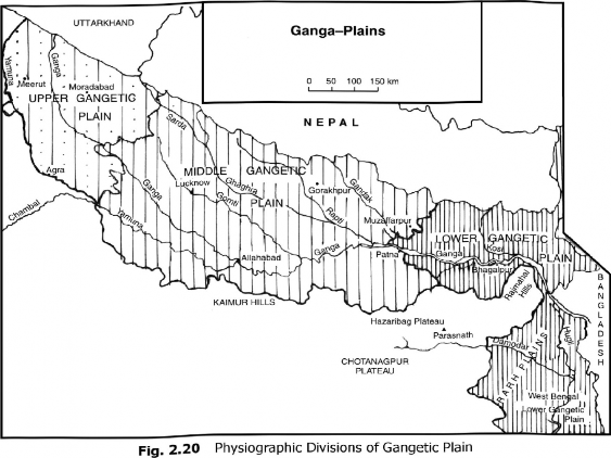
3. The Ganga Plains (Total area 357,000 sq. km.)
The Ganga Plains lie between the Yamuna catchment in the west to the Bangladesh border in the east (Fig. 2.20). It is about 1400 km from west to east and has an average width of 300 km from north to south. The general gradient of the plain is about 15 cm per km from north-west to south east. The maximum height of this plain is found to the north of Saharanpur (276 m) followed by Roorkee (274 m), Agra (169 m), Kanpur (125 m), Allahabad (98 m), Patna (53 m), Kolkata (6 m), and Sagar Island only 3 metres above sea level.
The main topographical variations in the plains include, Bhabar, Tarai, Bhangar, Khadar, river bluffs (levees), abandoned courses, Khols, dead-channels, Bills, Tais, and badlands. The Ganga Plains can be subdivided into the following sub-regions:
(a) The lipper Ganga Plain The Upper Ganga Plain includes the Ganga-Yamuna Doab, Rohilkhand Division and parts of the Agra Division. The catchment area of the Yamuna river makes its western boundary, Shiwaliks in the north and 125 m contour in the south. The elevation of the Upper Ganga Plain varies between 100 m to about 300 m. In addition to Ganga and the Yamuna, it is traversed by the Kali and Sharda rivers. A unique feature of the Upper Ganga Plain is the presence
of Bhur (undulating, aeolian sandy deposits). Devoted to sugarcane, rice, wheat, maize, pulses, mustard, fodder, vegetables and orchards, it is one of the most productive plains of India in which the Green Revolution is a big success (Fig. 2.20).
(b) The Middle Ganga Plain Sprawling over an area of about 144,400 sq km, the Middle Ganga Plain includes central and eastern Uttar Pradesh, and the Bihar Plains up to Muzaffarpur and Patna. In the north, it is bounded by the Shiwaliks along the Indo-Nepal border. It has thick alluvial deposits with less Kankar formation. The region is homogeneous and featureless where monotony is broken by river levees, bluffs, ox-bow lakes, Dhus, Tais, Jala And Chaurs (marshy lands). Being a low gradient plain, the rivers often change their courses in this region. Gandak and Kosi are the main left hand tributaries, while the Son is an important right hand tributary of the Ganga in the Middle Ganga Plain.
(c) The Lower Ganga Plain (Area 80,970 sq km) The Lower Ganga Plain extends from Patna in the west, the foot of Darjeeling Himalaya in the north to the Bay of Bengal in the south. It is bordered by Assam and Bangladesh in the east and the Chotanagpur Plateau in the west. In the lower part of the Lower Ganga Plain is Sundarban Delta. The plain has a monotonous surface.
The eastern part of the plain is drained by the Tista,Jaldhakia, Sankosh joining the Brahmaputra, and the western part by the Mahananda, Ajay and Damodar. In the extreme south-west, Kasai and Subamarekha are the main rivers. The general slope of this plain is towards south and south-east.
The Lower Ganga Plain has been formed by the downwarping of a part of the Peninsular India between Rajmahal Hills and the Meghalaya Plateau and subsequent sedimentation by the Ganga and the Brahmaputra rivers. The plain has a monotonous surface dissected frequently by the channels of the main streams and their tributaries.
Rahr Plain: Lying to the east of the Chotanagpur Plateau, it is a part of the Lower Gangetic Plains. Drained by the Damodar and Subarnarekha, it is covered by the lateritic-alluvium soils. Soil erosion is the main problem of the Rahr plain. Rice, maize and pulses are the main crops of the Rahr plain.
Sundarbans'. The largest mangrove swamp in the world, the Sundarbans, or the beautiful forest, gets its name from the Sundari tree which grows well in marshland. It is home to the Royal Tiger and crocodiles.