
1.1.1.3. Distribution of Roads in India
India has one of the largest road networks in the world with a total length of 46.9 lakh km (2013). About 65% of freight and 80% passenger traffic is carried by the roads. National Highways in India constitute only about 1.7% of the road network but carry about 40% of the total road traffic. Number of vehicles has been growing at an average pace of 10.16% per annum over the last five years.
India has a long tradition of building roads since the times of Chandragupta Maurya and Asoka. The real progress was made during Mughal period, when Sher Shah Suri constructed a road between Peshawar and Kolkata. It is now called Grand Trunk (G.T.) Road. Road transport in modern sense was very limited in India before World War-II. The first serious attempt was made in 1943 when ‘Nagpur Plan’ was drawn. This plan could not be implemented due to lack of coordination among the princely states and British India. After Independence, twenty-year road plan (1961) was introduced to improve the conditions of roads in India. However, roads continue to concentrate in and around urban centres. Rural and remote areas had the least connectivity by road. Currently, the Indian road network consists of National Highways, State Highways, District roads and Village roads. Besides these, there are International highways and the Expressways, which are of recent development.
1.1.1.3.1. National Highways
These are the main roads, which are constructed and maintained by the Central Government through National Highway Authority of India (NHAI)1, which was established in 1995. These roads are meant for interstate movement and connect the state capitals, important ports, major cities and railway junctions. The total length of the National Highways was about 19,700 km in 1951. It has increased to about 70,934 km in 2012. The National Highways are only 2 per cent of the total road length in India, but these roads carry about 40 per cent of the total road traffic of India.

As of now about 26 per cent (18,350 km) of the total length of National Highways (NHs) is single lane/intermediate lane, about 51 per cent (36,031 km )is two-lane standard, and the balance 23 per cent (16,553 km)is four-lane standard or more.
The NHDP project is composed of the following phases:
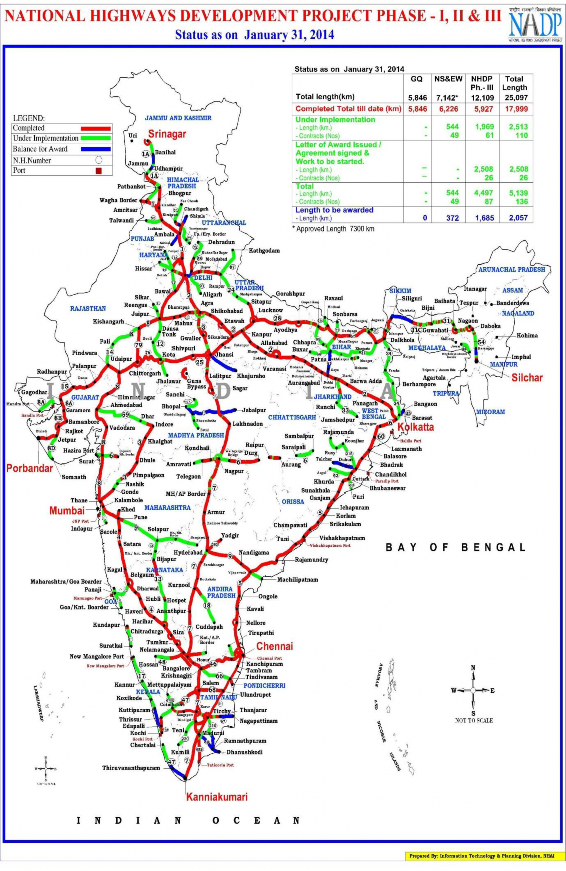
Phase I: The Golden Quadrilateral (GQ) connecting the four major cities of Delhi, Mumbai, Chennai and Kolkata. This project connecting four metro cities would be 5,846 km (3,633 mi). Total cost of the project is Rs.300 billion (US$6.8 billion), funded largely by the government’s special petroleum product tax revenues and government borrowing. In January 2012, India announced the four lane GQ highway network as complete.
Phase II: North-South and East-West corridors comprising national highways connecting four extreme points of the country. The North-South and East-West Corridor (NS-EW; 7,300 km) connecting Srinagar in the north to Kanyakumari in the south, including spur from Salem to Kanyakumari (Via Coimbatore and Kochi) and Silchar in the east to Porbandar in the west. Total length of the network is 7,300 km (4,500 mi). The Golden Quadrilateral and the corridors will also be connected to 10 major ports of India, namely Kandla, Jawaharlal Nehru Port, Marmagao, New Mangalore, Kochi, Tuticorin, Ennore, Vishakhapatnam, Paradip and Haldia, through a road length of 363 km.
Phase III: The government recently approved NHDP-III to upgrade 12,109 km (7,524 mi) of national highways on a Build, Operate and Transfer (BOT) basis, which takes into account high- density traffic, connectivity of state capitals via NHDP Phase I and II, and connectivity to centres of economic importance.
Phase IV: The government is considering widening 20,000 km (12,000 mi) of highway that were not part of Phase I, II, or III. Phase IV will convert existing single lane highways into two lanes with paved shoulders. The plan will soon be presented to the government for approval.
Phase V: As road traffic increases over time, a number of four lane highways will need to be upgraded/ expanded to six lanes. The current plan calls for upgrade of about 5,000 km (3,100 mi) of four-lane roads, although the government has not yet identified the stretches.
Phase VI: The government is working on constructing expressways that would connect major commercial and industrial townships. It has already identified 400 km (250 mi) of Vadodara (earlier Baroda)-Mumbai section that would connect to the existing Vadodara (earlier Baroda)- Ahmadabad section. The World Bank is studying this project. The project will be funded on BOT basis. The 334 km (208 mi) Expressway between Chennai—Bangalore and 277 km (172 mi)

1 The National Highways Authority of India (NHAI) was formed in 1995. It is an autonomous body under the Ministry of Surface Transport. It is entrusted with the responsibility of development, maintenance and operation of National Highways. This is also the apex body to improve the quality of the roads designated as National Highways.
Expressway between Kolkata—Dhanbad has been identified and feasibility study and DPR contract has been awarded by NHAI.
Phase VII: This phase calls for improvements to city road networks by adding ring roads to enable easier connectivity with national highways to important cities. In addition, improvements will be made to stretches of national highways that require additional flyovers and bypasses given population and housing growth along the highways and increasing traffic. The government has not yet identified a firm investment plan for this phase.
1.1.1.3.2. The State Highways

These highways are constructed and maintained by the State Governments through their respective Public Works Departments (PWD). The State Highways provide linkages with the National Highways, district headquarters, important towns, tourist centres and minor ports and carry the traffic along major centres within the state. These arterial routes provide connectivity to important towns and cities within the state with National Highways or State Highways of the neighbouring states. Their total length is about 137,712 km. These constitute 4 per cent of total road length in the country.
1.1.1.3.3. The District Roads
These roads are constructed and maintained by Zila Parishads and the Public Works Departments. The district roads mostly connect the district headquarters with the main towns and large villages within the districts. Now most of these roads are metalled roads and provide accessibility to the rural areas. The total length is about 4,70,000 km. They account for 14 per cent of the total road length of the country.
1.1.1.3.4. The Village Roads
These roads are constructed and maintained by the Village Panchayat. They connect the villages with the neighbouring towns and cities. These roads made great progress under the Pradhan Mantri Grameen Sadak Yojana (PMGSY). Under this scheme, the all weather roads are constructed to provide easy access to the villages. Their total length in 2005 was 26,50,000 km, which was about 80 per cent of all types of roads in India.
1.1.1.3.5. The Border Roads
The Border Roads Organisation (BRO) was established in 1960. Its main aim was to plan and construct roads of strategic importance in the northern and north-eastern border areas of the country. BRO has constructed roads in high altitude mountainous areas. Apart from this main work, the BRO also undertakes snow clearance in high altitude areas.
1.1.1.3.6. Expressways
Expressways are the highest class of roads in the Indian Road Network. An expressway is a controlled-access highway; it is a highway that controls entrances to it and exits from it by incorporating the design of the slip roads for entry and exit into the design of the highway itself. Expressways make up approximately 1,208 km (751 mi) of India's road network, as of 2013. The expressways in use are:
National Highway | Route | Distance |
NH-1 | Jalandhar – Uri | 663 |
NH-1A | New Delhi-Ambala-Jalandhar-Amritsar | 456 |
NH-2 | Delhi-Mathura-Agra-Kanpur-Allahabad-Varanasi- Kolkata | 1465 |
NH-3 | Agra-Gwalior-Nasik-Mumbai | 1161 |
NH-4 | Thane and Chennai via Pune and Belgaum | 1235 |
NH-5 | Kolkata - Chennai | 1533 |
NH-6 | Kolkata – Dhule | 1949 |
NH-7 | Varanasi – Kanyakumari | 2369 |
NH-8 | Delhi-Mumbai-(via Jaipur, Baroda and Ahmedabad) | 1428 |
NH-9 | Mumbai-Vijayawada | 841 |
NH-10 | Delhi-Fazilka | 403 |
NH-11 | Agra- Bikaner | 582 |
NH-12 | Jabalpur-Jaipur | 890 |
NH-13 | Sholapur-Mangalore | 691 |
NH-15 | Pathankot-Samakhiali | 1526 |
NH-17 | Panvel-Edapally | 1269 |
NH-22 | Ambala-Shipkitr | 459 |
NH-28 | Lucknow-Barauni | 570 |

List of Main National Highways in India
1) Greater Noida – Agra Yamuna Expressway (165 kilometres)
2) Ahmadabad Vadodara Expressway (95 kilometres)
3) Mumbai-Pune Expressway (93 kilometres)
4) Jaipur-Kishangarh Expressway (90 kilometres)
5) Allahabad Bypass Expressway (86 kilometres)
6) Durgapur Expressway (65 kilometres)
7) Ambala Chandigarh Expressway (35 kilometres)
8) Chennai Bypass Expressway (32 kilometres)
9) Delhi-Gurgaon Expressway (28 kilometres)
10) NOIDA-Greater NOIDA Expressway (24 kilometres)
11) Delhi-NOIDA Flyway (23 kilometres)
12) Mumbai Nasik Expressway (150 kilometres)
13) PVNR Hyderabad Airport Expressway (12 kilometres)
14) Hyderabad ORR Expressway (150 kilometres)
15) Guntur-Vijayawada Outer ring road Expressway (46 Kilometres) Outer Ring Road, Guntur & Vijayawada
16) Coimbatore Bypass expressway (28 kilometres)
1.1.1.3.7. The Asian Highway (AH)

The Asian Highway (AH) project, also known as the Great Asian Highway, is a cooperative project among countries in Asia and Europe and the United Nations Economic and Social Commission for Asia and the Pacific (ESCAP), to improve the highway systems in Asia. It is one of the three pillars of the Asian Land Transport Infrastructure Development (ALTID) project, endorsed by the ESCAP commission at its 48th session in 1992, comprising Asian Highway, Trans-Asian Railway (TAR) and facilitation of land transport projects. Agreements have been signed by 32 countries to allow the highway to cross the continent and also reach to Europe. Some of the countries taking part in the highway project are India, Sri Lanka, Pakistan, China, Japan, South Korea and Bangladesh. Most of the funding comes from the larger, more advanced Asian nations like Japan, India and China as well as international agencies such as the Asian Development Bank.
The following are the routes which pass through India –
1) AH1; Petrapole to Atari via NH 1 & 2
2) AH42, 3,754 km (2346 miles); Lanzhou, China (on AH5) to Barhi, India (on AH1)
3) AH43, 3,024 km (1892 miles); Agra, India (on AH1) to Matara, Sri Lanka
4) AH44, 107 km (67 miles); Dambulla, Sri Lanka (on AH43) to Trincomalee, Sri Lanka
5) AH45, 2,030 km (1269 miles); Kolkata, India (on AH1) to Bangalore, India (on AH43/AH47)
6) AH46, 1,967 km (1,222 miles); named Great Eastern Highway within India from its East Coast to West Coast - Hazirah-Surat-Jalgaon-Howrah(Kolkata) till AH2.
7) AH47, 2,057 km (1286 miles); Gwalior, India (on AH43) to Bangalore, India (on AH43/AH45)
8) AH48, 1 km (.625 miles); Phuentsholing, Bhutan to border between Bhutan and India