7.2. Tropical Cyclones
The tropical cyclone develops from the ‘warm core’ of extremely low pressure area in the tropical oceanic areas. They are energized from the condensation process in the towering cumulonimbus clouds, surrounding the centre of the storm. The arrangement of isobars is almost circular. With continuous supply of moisture from the sea, the storm is further strengthened. On reaching the land the moisture supply is cut off and the storm dissipates. The place where a tropical cyclone crosses the coast is called the landfall of the cyclone. The conditions favourable for the formation and intensification of tropical storms are:
♤ Large sea surface with temperature higher than 27° C
♤ Presence of the Coriolis force

♤ Small variations in the vertical wind speed
♤ A pre-existing weak low-pressure area or low-level-cyclonic circulation -
♤ Upper divergence above the sea level system.
Large and continuous supply of warm and moist air from the ocean provides necessary energy in the form of latent heat of condensation. Coriolis force causes cyclonic circulation. At the equator, the Coriolis force is zero and the wind blows perpendicular to the isobars. The low pressure gets filled instead of getting intensified. That is the reason why tropical cyclones are not formed near the equator.
Because of small variations in the vertical wind speed or wind shear, cyclone formation processes are limited to latitudes equatorword of the sub-tropical jet stream. It is the pre- existing low pressure area which intensifies and develops as cyclone. It must be pointed out that only a few of these disturbances develop into true tropical cyclones. Upper divergence helps in ascending air currents to be pumped out to maintain the low pressure at the centre of the cyclone.
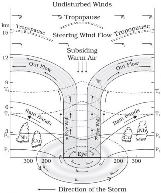
Tropical cyclone shown in figure 31 has following features:
♤ Eye – it is the centre of cyclone around which strong spirally winds circulate in a mature tropical cyclone. It is a region of calm with subsiding air.
♤ Eye Wall – there is a strong spiraling ascent of air to greater height reaching the tropopause. The wind reaches maximum velocity in this region, reaching as high as 250 km per hour. Torrential rain occurs here. From the eye wall rain bands may radiate and trains of cumulus and cumulonimbus clouds may drift into the outer region.
♤ The diameter of the circulating system can vary between 150 and 250 km.
♤ The diameter of the storm over the Bay of Bengal, Arabian Sea and Indian Ocean is between 600 - 1200 km. The system moves slowly about 300 - 500 km per day.