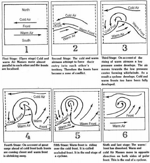
7.1. Extra-Tropical Cyclones
Extra-tropical cyclones are the weather disturbances in the mid and high latitude, beyond the tropics. These latitudes are an area of convergence where contrasting air masses generally meet to form polar fronts. The stages of development of extra-tropical cyclone are described below with diagram.
♤ Initially, the front is stationary (figure 29-1).
♤ In the northern hemisphere, warm air blows from the south and cold air from the north of the front. When the pressure drops along the front, the warm air moves northwards and the cold air move towards, south setting in motion an anticlockwise cyclonic circulation(figure 29-2).
♤ The cyclonic circulation leads to a well developed extra tropical cyclone, with a warm front and a cold front (figure 29-3).
♤ The warm air glides over the cold air and a sequence of clouds appear over the sky ahead of the warm front and cause precipitation (figure 29-4).
♤ The cold front approaches the warm air from behind and pushes the warm air up (figure 29-5). As a result, cumulus clouds develop along the cold front.
♤ The cold front moves faster than the warm front ultimately overtaking the warm front. The warm air is completely lifted up and the front is occluded and the cyclone dissipates (figure 29-6).