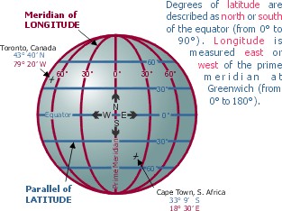
8.1. Latitude
Latitude is the angular distance of a point on the earth’s surface, measured in degrees from the centre of the earth. It is parallel to a line, the equator, which lies midway between the poles. These lines are therefore called parallels of latitude, and on a globe are actually circles, becoming smaller polewards. The equator represents 0° and the North and South Poles are 90°N and 90°S. Between these points lines of latitude are drawn at intervals of 1°. For precise location on a map, each degree is sub-divided into 60 minutes and each minute into 60 seconds. The most important lines of latitude are the equator, the tropic of Cancer (23⅟2°N.), the tropic of Capricorn (23⅟2°S.), the Arctic Circle (66⅟2°N.) and the Antarctic Circle (66⅟2°S.). As the earth is slightly flattened at the poles, the linear distance of a degree of latitude at the pole is a little longer than that at the equator. For example at the equator (0°) it is 68.704 miles, at 45° it is 60.054 miles and at the poles it is 69.407 miles. The average is taken as 69 miles. This is
a useful figure and can be used for calculating distances to any place. Bombay is 18.55°N; it is therefore 18.55*69 or 1280 miles from the equator.