Figure 19 – Sea and Land Breezes
Sea Breeze | Land Breeze | |||||
During the day the land heats up faster and becomes warmer than the sea. The heated air rises giving rise to a low pressure area, whereas the sea is relatively cool and the pressure over sea is relatively high. | In the night, the land cools up faster than the surrounding sea. This creates relatively high pressure on land. | |||||
Pressure gradient is created from sea to land. | Pressure gradient is created from land to sea. | |||||
the wind blows from the sea to the land as the sea breeze | the wind blows from the land to the sea as the land breeze | |||||
Reaches afternoon | at | maximum | intensity | in | mid- | Reaches at peak shortly before the sunrise |
Helpful for fishermen in returning from sea after a good catch. | In morning, fishermen enter into sea with the help of land breeze and stays there till mid- afternoon. | |||||
Table 2 – land and sea breezes
4.8.2. The Mountain and Valley Breezes
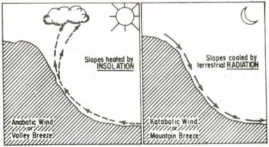
Another combination of local winds that undergoes a daily reversal consists of the mountain and valley breezes (figure 20). During the day the slopes get heated up more than the valleys. Hence, the pressure is low over the slopes while it is comparatively high in the valleys below. Air moves up from slope and to fill the resulting gap the air from the valley blows up the valley. This wind is known as the valley breeze or anabatic wind. The valley breeze is sometimes accompanied by the formation of cumulus cloud near mountain peaks to cause orographic rainfall.
During the night the slopes get cooled and the dense air descends into the valley as the mountain wind. The cool air, of the high plateaus and ice fields draining into the valley is called mountain breeze or katabatic wind.

