3.2. The Northern Plains
The northern plains of India are remarkably homogeneous surface with an imperceptible slope. In fact, they are a featureless alluvial fertile plains formed by the alluvial deposits brought by the rivers – the Indus, the Ganga and the Brahmaputra along with their tributaries and Vindhyan rivers flowing towards north. The plain extends from the arid and semi-arid areas of Rajasthan in the west to Brahmaputra valley in the east. The average width of these plains varies between 150-300 km. The maximum depth of alluvium deposits varies between 1,000- 2,000 m. Its average height is 200 metres above the mean se level. Due to a very gentle slope towards the sea, the rivers in this plain flow very leisurely and at times even sluggishly. The slope from Varanasi upto the mouth of Ganga is only 10 cm. per km. The land around Ambala is a bit more elevated.
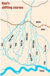
Due to almost flat land, changing river courses in the areas of frequent floods is a unique geomorphic process in the plains. The Kosi (The Sorrow of Bihar) is one of two major tributaries of Ganga, the other river being Gandak, draining the plains of north Bihar, the most flood-prone area of India. Over the last 250 years, the Kosi River has shifted its course over 120 kilometres and the unstable nature of the river is attributed to the heavy silt which it carries during the monsoon season (figure 12).From north to south, northern plains can be divided into three major zones: the Bhabar, the Tarai and the alluvial plains. The alluvial plains can be further divided into the khaddar and the Bhangar.