Figure 6 – Himalaya’s syntaxes at NP (Nanga Parbat) and NB (Namcha Barwa)
2.3. Indo-Ganga-Brahmaputra Plain
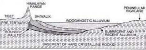
The third geological division of India comprises the plains which lie to the south of Shiwalik formed by the river system Indus, the Ganga and the Brahmaputra. Originally, it was a geo- synclinal depression which attained its maximum development during the third phase of the Himalayan mountain formation approximately about 64 million years ago. It is an aggradational plain formed by the alluvial deposits of rivers originating in Himalayas in north and the Peninsular plateau in South. Since then, it has been gradually filled by the sediments brought by the Himalayan and Peninsular rivers. Average depth of alluvial deposits in these plains ranges from 1,000-2,000 m. Some geologists are of the opinion that Great plains are a remnant of the Tethys Sea. After the upheaval of Shiwalik, the remaining part of the Tethys was left as a large trough. Because the Himalayas were rising during that period, rivers experienced rejuvenation and greater quantity of eroded material which increased the thickness of alluvium in this trough (figure 7).