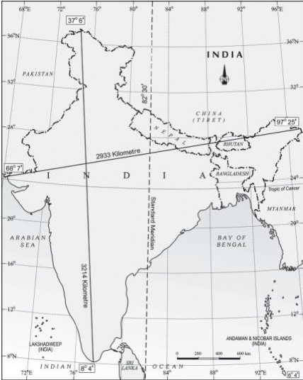
Figure 1 – India in the world
Lakshadweep islands in Bay of Bengal and Arabian Sea respectively. Andaman and Nicobar islands make southern boundary of India Union at 6°45'E in Bay of Bengal. The southernmost point of the India Union “Indira Point” got submerged under the sea water in 2004 during the Tsunami.
If you work out the latitudinal and longitudinal extent of India, they are roughly about 30 degrees, whereas the actual distance measured from north to south extremity is 3,214 km, and that from east to west is only 2,933 km (figure 2). Why is it so? This is because the east-west distance between two successive meridians of longitude along the equator is at its maximum - 111 km. This, however, goes on decreasing as one moves from the equator to the poles, where it is zero. This is because all the meridians of longitude merge in a single point at the poles - both North and South. On the other hand, the north-south distance between any two successive parallels of latitude along any meridian of longitude remains almost uniform, i.e., 111 km.
1.1. Indian Standard Time (IST)
While the sun rises in the northeastern states about two hours earlier as compared to Jaisalmer, the watches in Dibrugarh, Imphal in the east and Jaisalmer, Bhopal or Chennai in the other parts of India show the same time. Why does this happen? What is Indian Standard Time (IST)? What is the use of standard meridian (figure 2)? Variation of nearly 30degree in longitude causes a time difference of

