
Ports
There are 12 major and 200 minor ports in India. Ports not only play a crucial role in facilitating international trade, they also act as fulcrums of economic activity and development in their surrounding areas. India has about 7517 km of main coastline spread over 13 states/union territories, and studded with 12 major ports and 200 non major ports (minor and intermediate). Of the nonmajorports, around 60 are handling traf fic. The major ports are under the jurisdiction of the Central Government, while the minor and intermediate ports are managed and maintained by the respective state governments. The number of cargo vessels handled at major port is about 16,500 per annum.
The total traffic carried by both the major and minor ports during 2005-06 was estimated at around 570 million tonnes. The 12 major ports carry about 75 per cent of the total traffic with Vishakhapatnam as the top traffic handler in each of the last .six years (2000-01 to 2006-07). Major Seaports of India The major seaports of India are: (i) Chennai, (ii) Cochin, (iii) Ennore, (iv) Jawaharlal Nehru Port (Nhava Sheva), (v) Kandla, (vi) Kolkata/ Haldia, (vii) Mormugao, (viii) Mumbai, (ix) New Mangalore, (x) Paradwip, (xi) New Tuticorin, and (xii) Vishakhapatnam (Fig. 12.6). The salient geographical features of the major seaports of India have been described briefly here:
1. Chennai Situated along the northern coast of Tamil Nadu, it is an artificial seaport. It spreads over an area of about 80 hectares with an average depth of about 16 metres. The harbour has an entry from the north. It can accommodate 22 vessels. The main exports from the Chennai port are food-grains, hides and skins, iron-ore, mica, oil-cake, sugar, turmeric, timber, and tobacco. The port imports chemicals, coal, cotton, cotton-goods, edible-oils, fertilisers, iron and steel, machinery, metals, and petroleum.
2. Ennore Situated about 20 km to the north of Chennai, Ennore is a natural harbour. It was developed to ease the pressure of the Chennai-seaport. Ennore exports hides, machinery, mica, rice, and sugar. The principal imports are cement, cotton, edible-oils, fertilisers, machinery, and petroleum products.
3. Jawahar Lal Nehru (Nhova Shiva) Port Situated about 14 km to the south of Mumbai, this seaport was developed to ease the pressure of the Mumbai seaport. It is a world-class port equipped with all the modern facilities. The seaport is connected by a four-lane Highway with the hinterland. India’s largest container port is Jawaharlal Nehru Port.
Independence to take up the place of Karachi which went to Pakistan. It is a tidal harbour in the Kandla Creek with an average depth of 10 metres. The port has a vast hinterland in the states of Gujarat, Rajasthan, I laryana, Punjab, Himachal Pradesh, andjammu and Kashmir. Its main imports are petroleum, fertilisers, phosphates, and sulphur, while the export includes bones, cotton, foodgrains, naptha, salt, and sugar.
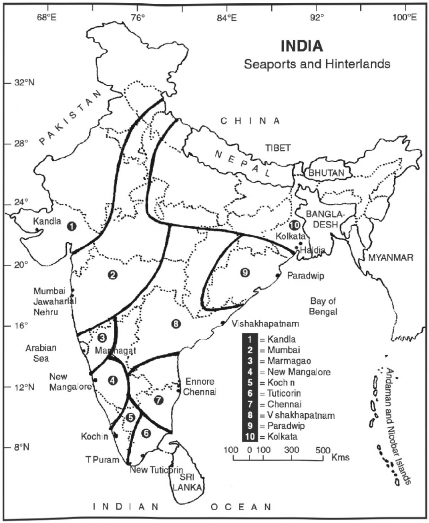
Fig. 12.6 Major Seaports and their Areas of Influence
5. Kochi Situated along the coast of Kerala, Kochi is a natural seaport and the largest shipyard in the country. The indigenous Aircraft Carrier for the Indian Navy is also presently under construction in the shipyard. It remains open for cargo traffic throughout the year. Being situated close to the Suez-Colombo route, it has great commercial and strategic importance. The main items of export mode of transportation in Indian transport network. It is a crucial component for the development of domestic industry and trade. Coastal shipping involves movement of goods and passengers from one port to another port within the country. India’s coastal Shipping Tonnage in December 2005 was 470 vessels with 8,04,612 GRT.
Coastal shipping has many advantages as given below:
1. It reduces the pressure on rail and road transport systems.
2. It is relatively pollution free.
3. It is less capital intensive.
4. It provides large employment.
5. It is the cheapest mode of transport.
6, It promotes coastal base industries such as fisheries and corals collection.
7. It promotes tourism.
Problems some of the important problems of the Indian ports are given below:
1. Indian ports are the most congested.
2. The ports are not adequately connected with the hinterland.
3. There is heavy pressure on container traffic. The largest container port in the world is Singapore which handles 23.19 million TEUs (twenty foot equivalent units). In comparison to this India’s largest container port handled roughly 2.67 million TEUs in 2005-06.
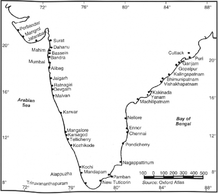
Fig. 12.7 Major Fishing Ports
India has about 14,500 km of navigable waterways which comprise rivers, canals, lakes, backwaters, and creeks. About 45 million tonnes of cargo is being moved annually by Inland Water Transport. It is a fuel-efficient and environment-friendly mode of transportation. Its operations are currently restricted to a few stretches in the Ganga-Hugli rivers, the Brahmaputra, the Barak river (Assam), the rivers in Goa, the backwaters of Kerala, inland waterways in Mumbai, and the deltaic regions of the Godavari-Krishna rivers. Besides the organised operations by mechanised vessels, country boats of various capacities also operate in various rivers, lakes, and canals. Data of cargo and passengermovement in unorganised sector (i.e., by country boats, etc.) has not been compiled, but it is a fact that substantial quantum of cargo and passengers are transported in the unorganised sector as well.
The Central Waler Transport Corporation (CIWTC) Constituted in 1967, it has its headquarters at Kolkata. It is mainly engaged in the transportation of goods by inland waterways in the Ganga, Brahmaputra, Hugli, and Sundarban regions. It is operating regular cargo service between Kolkata and Karimganj (Assam), Kolkata and Bangladesh, and Haldia and Patna.
Inland Waterways Authority of India (IWAI) The Inland Waterways Authority of India came into existence on October 27, 1986 for the development and regulation of inland waterways for shipping and navigation. The Authority primarily undertakes projects for development and maintenance of IWT infrastructure on national waterways through grant received from the Ministry of Shipping, Road Transport and Highways. The head-office of the Authority is located at NOIDA (UP near Delhi). The authority also has its regional offices at Guwahati, Kochi, Kolkata, and Patna and sub-offices at Allahabad, Bhagalpur, Farakka, Kollam, and Varanasi. The National Inland Navigation Institute is located at Patna.
National Waterways Following are National Waterways in India:
1. The Ganga between Allahabad-Haldia (1620 km).
2. The Sadiya-Dhubri stretch of the Brahmapputra (891 km).
3. The Kollam-Kottapuram stretch of West Coast Canal along Champakara and Udhyogmandal Canalas (205 km) in Kerala.
Factors Affecting Inland Waterways The following factors have a close bearing on the development and maintenance of inland waterways:
1. Fluctuation Regime of Riven Many of the rivers are seasonal. Even in the perennial rivers, like Brahmaputra, Ganga, Gandak, Kosi, and Yamuna, the discharge of water decreases substantially during the summer and winter months, while during the rainy season they are in floods. Both the conditions are not conducive for navigation.
2. Natural Obstacles Presence of waterfalls, cataracts, and rapids in the course of rivers hinder the development of inland navigation.
3. Silting of River Beds Silting of river bed reduces the depth of water and creates problems of navigation.
4. Water for Irrigation Diversion of water for irrigation reduces the quantity of water in the river channel.
5. Economically Unviablc The demand for waterways is not adequate as the people want fast movement of their commodities. This makes river transport economically unviable.
Managing about 95% of the country’s trade volume is carried by shipping (2012). India has a long history of shipping. The Scindhia Steam Navigation Co. was set up in 1919 on modern lines. At the time of Independence, there were only 59 ships with less than 2 lakh tonnes of Gross Registered Tonnage (GRT). Since Independence, India has made a significant progress in shipping and the shipping fleet had 872 ships (282 overseas and 590 coastal vessels (India 2010)). Coal, crude oil and natural gas are mainly transported by ship.
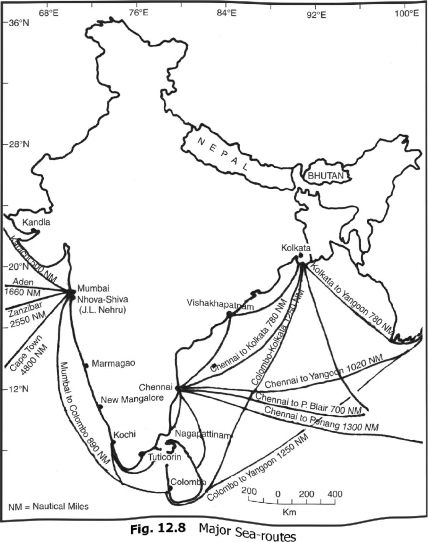
At present, shipping plays a significant role in the transport sector of the country’s economy. Nearly 95 per cent of the total trade volume is moved by sea making shipping the backbone of trade and economic growth. Today India has one of the largest merchant shipping fleet in the developing world. The major international sea routes of India have been shown in Fig- 12-8.
The Adam’s Bridge or Ram Sethu is a discontinuous chain of sandbars dotting 30 km stretch in the east-west direction between the southern tip of Rameswarani Island in India and Talaimannar in north-western Sri Lanka. It creates a geological divide between the Palk-Bay and the Gulf of Mannar which form part of the southern Kaveri Basin in the Bay of Bengal (Fig. 12.8).
The Sethu-Samudram Ship Channel Project (SSCP) of the Government of India envisages the dredging of the shallow ocean region in the Bay of Bengal to create an artificial 167 km long 300 m wide and 12 m deep channel like passage for (10,000-12,000 gross tonnage) ships across the island formations called Adam’s Bridge or Ram Sethu.
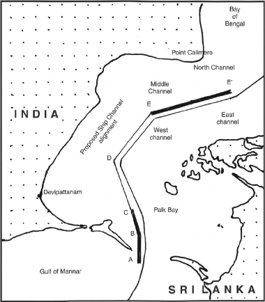
AB (17.3 Km) North BC (13.38 Km) North CD (37.44 Km)
DE (40.48 Km)
EE' (54.25 Km)
Adam's Bridge. Adam's Bridge Palk Bay Palk Bay Palk Strait Total 167.22 Km
Fig. 12.9 India—Ram Sethu Project
The proposal for channel linking the Palk-Strait and the Gulf of Mannar goes back to the British in i860 and since then several proposals have been made and six distinct alignments for the passage ‘Geological Evolution of Adam’s Bridge’ opined that Adam’s Bridge consists of sand-bars and coral formations. The possibility of formation of shoals in the shallow continental shelf as barrier bars (sandbars) appear to be the most plausible explanation for the evolution ol Rameswaram and Adam’s Bridge.
Thus all the scientific studies about the Ram Sethu suggest a consistent picture of natural process that led to the formation of Adam’s Bridge. It is not a man- made structure . It is merely a sand and coral formation. The reduction in the distances between Tuticorin and Chennai, Ennore, Vishakhapatnam, and Ilaldia/Kolkata, etc. has been given in Fig. 12.10.