
THE GREAT PLAINS OF INDIA
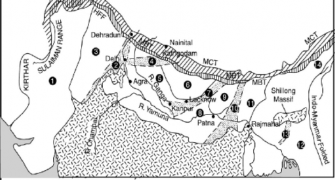
The Great Plains of India lies to the south of the Shiwalik separated by the Himalayan Front Fault (HFF). It is a transitional zone between the Himalayas of the north and Peninsular India of the south. It is an aggradational plain formed by the alluvial deposits of the Indus, Ganga, Brahmaputra and their tributaries. The plain stretches for about 2400 km from west to east. It has varying width; 90-100 km in Assam, 160 km near Rajmahal (Jharkhand), 200 km in Bihar, 280 km near Allahabad and 500 km in Punjab. In general, the width of the plain increases from east to west (Fig. 2.17).
The Great Plains of India consist largely of alluvial deposits brought down by the rivers originating in the Himalayan and the Peninsular region. The exact depth of alluvium has not yet been fully

Neogene Molasse (Shiwaliks) Lesser Himalayan
Frontal Zone
Pre-Gondwana Basement of Peninsular Region
| j Sub-Surface Ridges
I 1
♤ 250 km
1. Indus Basin
2. Delhi-Haridwar Ridge
3. Punjab Shelf
4. Delhi-Muzaffarnagar Ridge
5. West Uttar Pradesh Shelf
6. Sarda Depression
7. Faizabad Ridge
3. East Uttar Pradesh Shelf
9. Gandak depression
10. Munger-Saharsa Ridge
11. Purnia-Kasganj Graben
12. Bengal Basin 13 Madhupur Ridge
14. Kopili Graben
Fig. 2.17 The Great Plains of India and adjoining areas
Physiography
determined. According to recent estimates the average depth of alluvium in the southern side of the plain (north of Bundelkhand) varies between 1300 to 1400 metres, while towards the Shiwaliks, the depth of alluvium increases. The maximum depth of over 8000 metres has been reached near Ambala, Yamunanagar andjagadhri (Haryana).
The Great plains are remarkably homogeneous with little variation in relief features for hundreds of kilometers. The monotony of the physical landscape is broken at micro-level by the river bluffs, Bhurs, levees, dead-arms of river channels, the ravines and khols. Changing river courses in the areas of frequent floods is a unique geomorphic process in the plains. The frequent floods, although a cause of immense damage to life and property, lay down fresh layer of silts in the flood-plains every year, providing rich fertile soils.