
Methodology
The methodology used in the delineation of agro-ecological region is given below:
(i) Mean monthly temperature and mean monthly precipitation,
(ii) Type of soil.
(iii) Length of growing period.
In order to prepare an agro-ecological region map, the soil-scap (soil-map) was superimposed on bio-climatic map. On the resultant map, the growing period was incorporated, using GIS technology.
In the demarcation of agro-ecological regions of India, the agro-climatic regions of India have been sub divided on the basis of soil type. In the meso-regions thus obtained, the length of growing period (LGP) has been superimposed. This method has resulted into 20 agro-ecological regions and 60 agro-ecological sub- regions. The 20 agro-ecological regions of India have been plotted in Fig. 10.10.
The agro-ecological regions of India are:
1. Western Himalayas, cold arid eco-region with shallow soil and length of growing period less than 90 days.
2. Western Plain, Kachchh, and part of Kathiwara Peninsula, hot and arid ecoregion with desert and saline soils and growing period less than 90 days.
3. Deccan Plateau, hot arid region with red and black soils and growing period of less than 90 days.
4. Northern Plain and Central Highlands including Aravallis, hot semi-arid ecoregion, with alluvium-derived soils and growing period between varying between 90-150 days.
5. Central Malwa Highlands, Gujarat Plains, and Kathiawar Peninsula, hot semi-arid ecoregion with medium and deep black soils and growing period varying between 90 to 150 days.
6. Deccan Plateau, hot semi-arid ecoregion, with shallow and medium black soils and growing period varying between 90 to 150 days.
7. Deccan (Telengana)Plateau and Eastern Ghats, hot semi-arid ecoregion with red and black soil and growing period from 90 to 150 days.
8. Eastern Ghats, Tamil Nadu Plateau and Deccan (Karnataka), hot semi-arid ecoregion with red-loamy soils, and growing period of 90-150 days.
9. Northern Plain, hot sub-humid (dry) ecoregion, with alluvium soils, and growing period of 150-180 days.
10. Central Highlands (Malwas, Budelkhand, and Eastern Satpura), hot subhumid ecoregion, with black and red soils, and growing period 150-189 days.
11. Eastern Plateau (Chattisgarh), hot sub-humid ecoregion, with red and yellow soils, and growing period of 150-180 days.
12. Eastern (Chotanagpur) Plateau and Eastern Ghats, hot subhumid ecoregion, with red and lateritic soils, and growing period of 150-180 days.
13. Eastern Plain, hot sub-humid (moist) ecoregion, with alluvium soils, and growing period of 180-210 days.
14. Western Himalayas, warm sub-humid to humid with inclusion of perhumid ecoregion, with brown forest and podzolic soils, and growing period of 180-210 days.
15. Bengal and Assam Plain, hot sub-humid (moist) to humid (inclusion of perhumid) ecoregion with alluvial soils, and growing period 180 to 210 days.
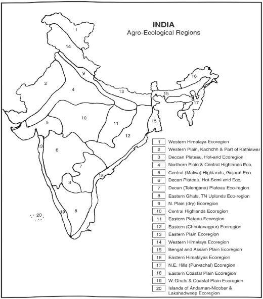
Fig. 10.10 Agro-Ecological Regions
16. Eastern Himalayas, warm perhumid ecoregion with brown and red soils, and gr owing period over 210 days.
17. North-Eastern Hills (Purvanchal), warm perhumid ecoregion with red and lateritic soils, and growing period over 210 days.
18. Eastern Coastal Plain, hot sub-humid to semi-arid ecoregion with coastal alluvium soils, and growing period varying from 90 to 210 days.
19. Western Ghats and Coastal Plain, hot humid per humid ecoregion, with red lateritic and alluvium soils, and growing period varying from 90 to 210 days.
20. The Islands of Andaman and Nicobar and Lakshadweep, hot humid to perhumid island ecoregion, with red loamy and sandy soils, and growing period over 210 days.
REFERENCES
Ahmad, A. and M.F. Siddiqui. ’’Crop Association Patterns in the Luni Basin.” In Geographer, 14 (1967):, 69— 80. Bansil, P.C. Agricultural Statistics of India. New Delhi: Arnold, Heinman, 1974.
Bansil, P.C. Agricultural Problems of India. New Delhi: Vikas Publication, 1977.
Bhatia, S.S. ”A New Method of Agricultural Efficiency in Uttar Pradesh.” In Economic Geography, 43 (1967): 244-60. Buck, J.L. Land Utilization in China. Shanghai: Commercial Press, 1937.
Eneyedi, G.Y. Geographical Types of Agriculture. Budapest, Hungary,1964 Government of India. Economic Survey. 2006-07.
Husain, M. ’’Crop Combination Regions of Uttar Pradesh: A Study in Methodology.” In Geographical Review of India, 34 (1972): 134-156. Husain, M. Agricultural Geography. New Delhi: Inter India Publications, 1979.
Husain, M. Systematic Agricultural Geography. Jaipur: Rawat Publications, 1996.
Kendall, M.G. “The Geographical Distribution of Crop Productivity in England.” In Journal of the Royal Statistical Society, 102 (1939): 21-48. Khusro, AM. “Returns to Scale in Agriculture.” In Indianjoumal of Agricultural Economics, 19 (1973): .52-64.
Morgan, W.B., and RJ. Munton. Agricultural Geography. London: Methuen & Co.
Sapre, S.G., and V.D. Deshpande. ’’Inter District Variations in Agricultural Efficiency in Maharashtra State.” In Indian Journal of Agricultural Economics, 19 (1964): 242-52.
Shafi, M. “Measurement of Agricultural Efficiency in Uttar Pradesh.” In Economic Geography, USA, 36 (1960): 304-314. Shafi, M. “Perspective on the Measurement of Agricultural Productivity.” In The Geographer, 1 (1974).
Shafi, M. Agricultural Geography. Delhi: Pearson Education, 2006.
Singh, G.B. Transformation ofAgriculture. Kurukshetra: Vishal Publications, 1979. Singh, J. An Agricultural Atlas of India. Kurukshetra: Vishal Publications, 1974.
Singh, J. and S.S. Dhillon. Agricultural Geography. New Delhi: Tata McGraw Hill, 1984. Stamp, L.D. Our Developing World. 108-09. London, 1960
Symon, L. Agricultural Geography. London, 1968.
Weaver, J.C. “Crop Combination Regions in the Middle West.” In Economic Geography, 32 (1954): 1—47.
Whittlesey, D. “Major Agricultural Regions of the Earth.” In Annals of the Association of American Geographers, 26 (1936): 100-240.

