AGRO-CLIMATIC REGIONS OF INDIA
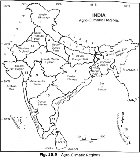
India has great variations in the geo-climatic, socioeconomic, and agricultural practices. The variations in the geo-ecological and socioeconomic conditions have closely influenced the agricultural activities. For the planning of agriculture, the Planning Commission and the National Remote Sensing Agency (NRSA) have divided the country into 15 agro climatic regions (Fig. 10.9). The main objectives of agro climatic regions are
(i) to optimise agricultural production
(ii) to increase farm income
(iii) to generate more rural employment
(iv) to make a judicious use of the available irrigation water
(v) to reduce the regional inequalities in the development of agriculture.
These agro-climatic regions are as under:
1. The Western Himalayan Region
2. The Eastern Himalayan Region
3. The Satluj-Yamuna Plain
4. The Upper Ganga Plain
5. The Middle Ganga Plain
6. The Lower Ganga Plain
7. The Eastern Plateau and Hills
8. The Aravalli Malwa Upland
9. The Plateau Maharashtra
10. The Deccan Interior
11. The Eastern Coastal Plain
12. The Western Coastal Plain
13. The Gujarat Region
14. The Western Rajasthan
15. The Islands (Andaman and Nicobar and Maldives)

