
AGRICULTURAL INTENSITY
Cropping intensity has been defined as the ratio between the net sown area and the gross or total cropped area. The double and multiple cropped area added into the net cultivated area gives the
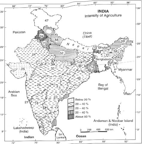
Fig. 10.3 Statewise Intensity of Agriculture (2005-06)
In the arbitrary choice method, the first two or the first three crops in the area are included and the rest of the crops are excluded from the combination. This is an unscientific method as the crops are excluded from the combination without any consideration of their percentage area and their monetary value.
The second method is known as the statistical method. This method being based on statistical formula is more scientific and reliable for the objective grouping of crops. In the field of agricultural geography, Weaver (1954) was the first to use statistical technique for the demarcation of crop combination regions of the Middle West (USA).
In his attempt to demarcate the agricultural regions of the Middle West (USA), Weaver based his analysis on acreage statistics. Weaver computed the percentage of total harvested cropland occupied by each crop that held as much as one per cent of the total cultivated land in each of the 1081 counties covered in his research work. He devised a rigorous approach that would provide total cropped area. The Department of Agriculture, Government of India, developed the following formula for the measurement of agricultural intensity;
Gross (total) cropped area
Agricultural Intensity =---—----7-----? 100
' Net cultivated area
The formula may be illustrated with the help of the following example:
Suppose the net cultivated area in a village is 1000 hectares and the total cropped area is 1500 hectares (800 hectares in the kharif and 700 hectares in the rabi
season)
The agricultural intensity in this village would be:
800 + 700
1000
X 100 = 150%
The agricultural intensity depends on the geo-climatic, pedological, socio-cultural, and infrastructural factors. Thus, the agricultural intensity is generally high in the well irrigated alluvial plains like Punjab, Haryana, and western Uttar Pradesh. Contrary to this, the agricultural intensity is low in the less rainfall recording areas, e.g. western Rajasthan, in which only one crop [kharif} is obtained during the season of general rains.
The agricultural intensity of India for 2005-06 has been plotted in Fig. 10.3. It may be observed from Fig. 10.3 that the agricultural intensity for the country as a whole is 132 per cent (2005-06). The highest agricultural density is in Punjab being 165 per cent, followed by Haryana 160 per cent and Uttar Pradesh 150 per cent. The main cause of high agricultural intensity in these states is the diffusion of short duration High Yielding Varieties of rice and wheat, availability of controlled irrigation, better accessibility to the market, storage facilities, and the progressive nature of the farmers who adopt the new innovations quickly and want to achieve a high standard of living. Contrary to this, the agricultural intensity is low in Rajasthan, north-western Gujarat, Hill states of North East India, Chhattisgarh, Jammu & Kashmir, Himachal Pradesh, and Uttarakhand (excluding its plain districts). In all these regions agriculture is rain-fed, the average annual rainfall is less than 60 cm. and irrigation facilities are not adequately available.