7. The Western Ghats
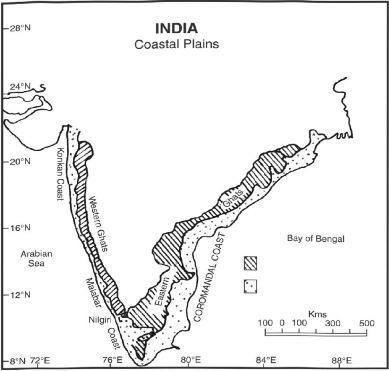
The Western Ghats in Sanskrit Sahyadris run parallel to the western coast for about 1600 km in the north south direction from the mouth of the Tapi river to Kanyakumari (Cape Camorin). The western slope of Sahyadri is steep while the eastern slope is gentle. These are block mountains formed due to the downwarping of a part of land into the Arabian Sea. The Sahyadris form a watershed of the peninsula. All the important rivers of Peninsular India, like the Godavari, Krishna and Kaveri rise from the Western Ghats. The western rivers merging into the Arabian Sea are swift. The Gersoppa (Jog Falls) on Sharvati is the highest waterfall in India. The average elevation of the Western Ghats varies between 1000 to 1300 metres (Fig. 2.3).
The important peaks of the Western Ghats are Kudermukh (1892 m), Pushpagiri (1714 m), Kalsubai (1646 m) and Sallier (1567 m), Mahabaleshwar (1438 m) and Harishchandra (1424 m). In the Nilgiris

Fig. 2.3 The Eastern and Western Ghats and the Coastal Plains
the Eastern Ghat joins the Western Ghat to form a mountain knot (Nilgiri) whose highest point is Anaimudi (2695 m). South of Nilgiri lies the Palghat (Palakkad Gap). South of Palghat, the Western Ghat is known as Anaimalai Hills. Anaimudi is the highest peak of Sahayadris Mt. is 2695 m above the sea level. The other important passes of the western Ghat are Thal Ghat and Bhor Ghat.
Bhor Ghat: (Joins Mumbai with Pune): Having an elevation of about one thousand metres above sea level, the Bhorghat joins Mumbai with Pune. It is one of the most busy passes in the Western Ghats. The frequency of trains and commercial vehicles is enormous.
Goran Ghat: Lying to the south of Mount Abu, it connects the city of Udaipur with Sirohi and Jalore in Rajasthan. It is about 1200 metres above sea level. The surrounding rocks are desolate, characterised by thorny bushes and cacti.
Haldighat'. It is a mountain pass in the Aravalli range of Rajasthan. Situated about 40 kilometres from Udaipur, it connects Rajsamand and Pali district. The name is believed to have come from the turmeric-co loured yellow soil. The mountain pass is historically important as the location of the historic battle of Haldighat which took place in 1576 between Rana Pratap Singh of Mewar and Raja Mansingh of Amber, General of the Mughal Emperor—Akbar the Great.
Harishchandra: The Harishchandra mountain ranges in the southern parts of Maharashtra from north-west to south-east. It stretches in the districts of Pune and Osmanabad. It is covered by degraded forests.
Jog Falls-. The short westward flowing Sharavati river pours down the Western Ghats, forming one of the highest waterfalls in the world at 250 m.
Kalsubai: Situated in the state of Maharashtra, it is one of the highest peaks of Western Ghats. It is 1646 metres above sea level. Inhabited by tribal people, its forest wealth has diminished due to deforestation.
Kudarmukh: Situated in the state of Karnataka, the Kudarmukh range (1892 m) is rich in iron ore. The iron-ore is of haematite and magnetite type. Iron ore from here is exported to Iran through the port at Mangalore.
Mahabaleshwar: Having an elevation of 1438 metres, Mahabaleshwar is one of the important peaks of the Western Ghats. It is a religious and cultural tourist attraction for domestic and international tourists.
The Nilgiri Hills: The Nilgiri Hills in the Western Ghats cover an area of about 2500 sq km and rise over 2500 m. Udhagamandalam, one of southern India’s most famous hill resorts, is located here. Palghat (Western Ghats; joins Coimbatore with Kochi and Kozhikode): Also known as the Palakkad Gap, it lies to the south of Nilgiri Hills. It has an elevation ranging from 75 to 300 in above the sea level. The width of this gap is about 25 km. It joins the state of Tamil Nadu with the seaports of Kerala. The river Gayitri flows through it from east to west.
Pushpagiri: This is one of the highest peaks of the Western Ghats. Its elevation is 1714 metres above the sea level. It is the abode of Dravidian tribes. The forests are however, degraded and soil erosion is the main problem.
Salher. Having an elevation of 1567 metres above sea level, the Salher peak lies between Malegaon and Nashik. It is inhabited by tribal people. Heavy deforestation has reduced its aesthetic beauty and created numerous ecological problems.
Thal Ghat (Western Ghats; joins Nashik with Mumbai): Located in the Sahyadri Ranges, Thal Ghat is over one thousand metres above sea level. The National Highway No. 3 and the Bhopal-Indore Railway Line pass through the Thal Ghat.
