
SPATIAL DISTRIBUTION OF FORESTS IN INDIA
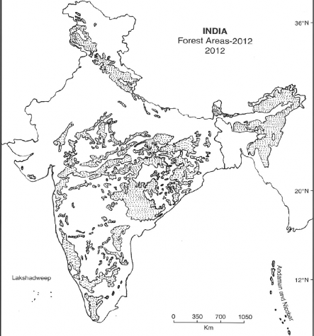
The total geographical area of India is 32,87,263 sq km, of which about 6,75,500 sq km—equal to 22.50 per cent—is under forests. According to the National Forest Policy (1952) about 33 per cent of the geographical area should be under forest. However, the existing forest area is much below the desired level. The areas under forest cover in India have been shown in Fig- 5.2. It may be observed from Fig. 5.2 that the Himalayan mountains, Bhabhar and Tarai, Western Ghats, Eastern Ghats, Bundelkhand, Baghelkhand, Chotanagpur Plateau, North-eastern Hills, Nilgiris, and the hills of Peninsular India are the main areas of Indian forests. Unfortunately, about 5 to 6 per cent of the total forest area of the country is under the category of degraded forests.
The forest area in India is much below the world average of 34.5 per cent and that of Brazil (57 per cent), Sweden (58 per cent), USA (42 per cent), Germany (41 per cent), and Canada (36 per cent). Similarly, the per head forest area in India is only 0.07 hectare as against the world average of 1.10 hectares, Canada at 23 hectares, Brazil 8.6 hectares, Australia 5 hectares, Sweden 4 hectares, and USA 3.5 hectares per head of population.
Table 5.1 The Region-wise Distribution of Forests in India
Geographical region | % of total forest area of India |
1. Himalayan Region 2. The Great Plains of India 3. Peninsular Plateau and Hills 4. Western-Ghats and Coastal Plains 5. Eastern-Ghats and Eastern Coastal Plains Total | 18.00 5.00 57.00 10.00 10.00 100.00 |
It may be observed from Table 5.2 that the largest forest area lies in Peninsular India accounting for 57 per cent of the total forest area of India. The Himalayan region has the second largest forest area having 18 per cent of the forest area of the country. The Eastern and Western Ghats have 10 per cent each, while the Gaugetic-Plains have only 5 per cent of the forest area of the country.
72°E80"E 86"E 77T
pig. 5.2 Forest Areas (2012)
Table 5.2 India—Statewise-Distribution of Forest
State/Union Territory | Geographical area | Total Forest Area | Percentage of forest area to geographical area |
State | |||
Andhra Pradesh | 275069 | 44637 | 16.23 |
Arunachal Pradesh | 83743 | 68045 | 81.25 |
Assam | 78438 | 27714 | 35.33 |
Bihar | 94163 | 5720 | 6.07 |
Chhattisgarh | 135191 | 56448 | 41.75 |
Goa | 3702 | 2095 | 56.59 |
Gujarat | 196022 | 15152 | 7.73 |
Haryana | 44212 | 1754 | 3.97 |
Himachal Pradesh | 55673 | 14360 | 25.79 |
Jammu & Kashmir | 222236 | 21237 | 9.56 |
Jharkhand | 79714 | 22637 | 28.40 |
Karnataka | 191791 | 36991 | 19.29 |
Kerala | 38863 | 15560 | 40.04 |
Madhya Pradesh | 308245 | 77265 | 25.07 |
Maharashtra | 307713 | 47482 | 15.43 |
Manipur | 22327 | 16926 | 75.81 |
Meghalaya | 22429 | 15584 | 69.48 |
Mizoram | 21081 | 17494 | 82.98 |
Nagaland | 16579 | 13345 | 80.49 |
Odisha | 155707 | 48838 | 31.37 |
Punjab | 50362 | 2432 | 4.82 |
Rajasthan | 342239 | 16367 | 4.78 |
Sikkim | 709 6 | 3193 | 44.99 |
Tamil Nadu | 130058 | 21482 | 16.52 |
Tripura | 10486 | 7065 | 67.38 |
Uttarakhand | 53483 | 23938 | 44.76 |
Uttar Pradesh | 240928 | 13746 | 5.71 |
West Bengal | 88752 | 10693 | 12.05 |
Union Territories | |||
Andaman & Nicobar Islands | 8249 | 6930 | 84.01 |
Chandigarh | 114 | 9 | 7.89 |
Dadra & Nagar Ilaveli | 491 | 219 | 44.60 |
Daman & Diu | 112 | 6 | 5.36 |
Delhi | 1483 | 111 | 7.48 |
Lakshadweep | 32 | 27 | 84.38 |
Poducherry | 480 | 36 | 7.50 |
India | 3287263 | 675538 | 22.50 |
Source: India 2005, Govt, of India Publication, New Delhi
An examination of Table 5.2 shows that Madhya Pradesh with 77,265 sq km has the largest area under forests in India, followed by Arunachal Pradesh with 68,045 sq km and Chhattisgarh with 56,448 sq. km. The rank of Odisha and Maharashtra are fourth and fifth respectively. With only 1754 sq. km, Haryana has the lowest area under forest among the states of India.
In terms of percentage, Mizoram with 83 per cent of its area under forest holds the first rank, followed by Arunachal Pradesh at 81 per cent and Nagaland at
80.50 per cent. The percentage of forest area in Meghalaya and Tripura are 69 anti 67 per cent respectively. The lowest percentage of forest area is in Haryana (3.97 per cent) followed by Rajasthan (4.78 per cent) and Punjab (4.8 per cent). In general, the hilly and mountainous states have more percentage of area under forest while the forest cover in the states with plains is almost insignificant.