
RAINFALL DISTRIBUTION
The distribution of rainfall in India is highly uneven. Its distribution is largely controlled by the nearness of the sea and the orographic features. The influence of the Western Ghats, the Plateau of Meghalaya, the north-eastern Hills, and the Himalaya Mountain is quite significant. The average annual distribution of rainfall in India has been shown in Fig. 4.20. It may be observed from Fig. 4.20 that the regional variations in the distribution of average annual rainfall over India are quite pronounced. In the southern parts of the Meghalaya Plateau (Mawsynram and Cherrapunji), the average annual rainfall is more than 1200 cm. However, it drops to 200 cm or less in the Brahmaputra Valley and the adjoining hills.
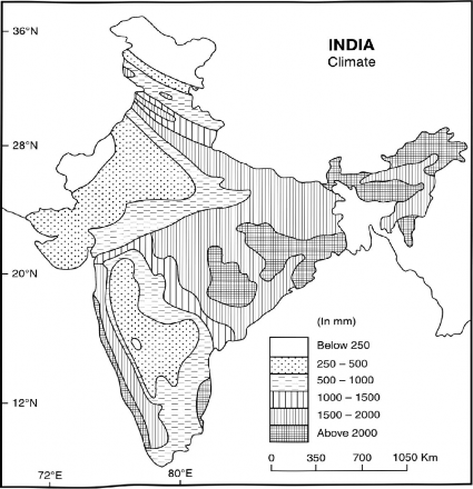
Fig. 4.20 Annual Rainfall (1950-2005)
In Peninsular India, the highest rainfall occurs along the Konkan and Malabar coasts. The isohyte of 150 cm rainfall runs southwards from the Gujarat coast, roughly parallel to the crest of the Western Ghats upto Kanniyakumari. In nortern India, it includes the hills of Himachal Pradesh, Uttarakhand, Chhattisgarh, eastern Maharashtra, and northern Andhra Pradesh. The regions lying to the west and south-west of this line have generally deficient rainfall where agriculture is largely vulnerable to drought. Along the Coromandal Coast of India the average annual rainfall is over 100 cm. In Punjab, Haryana and northern Rajasthan the mean annual rainfall is 60 cm or less. The lowest rainfall is recorded in western Rajasthan, the north-western parts of Gujarat, and Ladakh where it is less than 20 cm (Fig. 4.20).