3. The Season of General Rains
By the end of June, a low pressure area develops over Punjab and Rajasthan. The southern branch of the jet stream weakens and is finally withdrawn from the southern slopes of the Himalayas by midJune, leading to the formation of a dynamic depression over the surface thermal low. The Inter-Tropical-Convergence
(ITC) moves further northwards occupying a position of 25°N by midJune and allowing equatorial westerlies to gush in the subcontinent. The cyclonic vortices developed in the ITC cause rains in the country. The tropical easterly jet streams originating due to thermal heating of Tibet intensifies Indian Ocean high pressure cell from which south-east trade winds are pushed by the Antarctic circumpolar whirl to develop as south west monsoon.
In the northern plains of India, the temperature reaches its maximum inJune to break the monsoon. At places, the day temperature touches 46°C and more. The mean maximum temperature in the month ofjune atjodhpur reaches 41°C, Delhi 40°C, Allahabad 39°C, Kolkata 33°C, 29°C at Kochi and 23°C at Shimla and Srinagar. The diurnal range of temperature is high being about 30°C at Leh, and 15°C at Delhi. The diurnal range of temperature is, however, less than that of the month of May (Fig. 4.15).
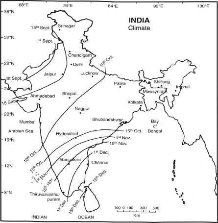
Generally in the afternoon of a scorching day, rains begin suddenly. This is known as a ‘monsoon burst’. The Arabian Sea current advances northwards by 1st June on the Kerala coast and reaches Mumbai by about 10thJune. By midJune, it spreads over Saurashtra, Kachchh and Madhya Pradesh.
The Bay of Bengal current first strikes Andaman and Nicobar islands by about 25th of May ami reaches Meghalaya, Mizoram and Tripura by about I’June. It rapidly spreads over most of Assam,
125 cm and Thanjavur only 85 cm of rainfall. The sub-branch of the Arabian Sea current which moves northwards through Kachchh, Gujarat and Rajasthan gives little rainfall to these regions due to the parallel alignment of the Aravallis. The Arabian sea current goes straight up to the western Himalayas, where it gives appreciable rainfall in Uttarakhand and Himachal Pradesh.
The Bay of Bengal current first dashes against the Myanmar coast, and obstructed by the eastern lulls, is deflected westward towards the Ganga Plain. This current causes the heaviest rainf all at Mawsynram (about 1200 cm) and Cherrapunji (1100 cm) annually. A major part of this rainfall occurs in the morning hours. Here also, the leeward sides of the Meghalaya Plateau receive lower rainfall; 150 cm and 160 cm at Shillong and Guwaliati, between June and September respectively. Moving westward, the Bay of Bengal current gives Kolkata 120 cm, Patna 105 cm, Allahabad 90 cm, Delhi 65 cm, Bikaner 25 cm and Srinagar (J&K) only 20 cm of rainfall between June and September (Fig- 4.16),
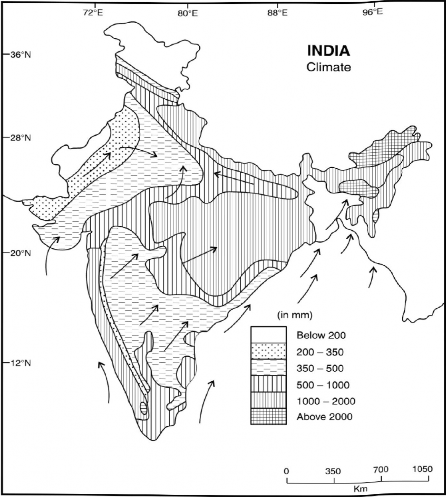
Fig. 4.16 Rainfall and Winds in July
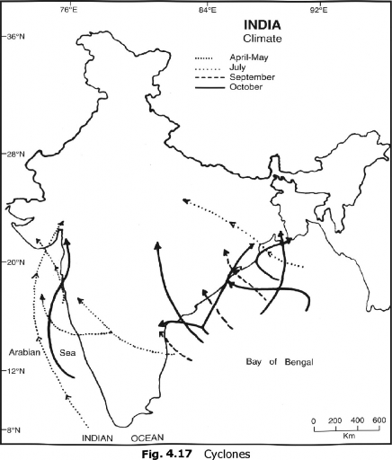
The weather and amount of rainfall received are also affected by a number of cyclonic depressions which enter the country through the Bay of Bengal and the Arabian Sea (Fig. 4.17). About 20 to 25 such depressions are developed during the monsoon period, of which some are stronger, causing immense damage to life and property of the people residing in the coastal areas of West—Bengal, Odisha, Andhra Pradesh, Tamil Nadu, and Gujarat. The cyclone of October 29,
1999 with a velocity of over 300km/h killed over one lakh people. More than two million houses were washed away and about 12 million people were rendered homeless. These cyclones are generally accompanied with heavy rain, the amount of which decreases going away from the coastal areas.
The distribution of rainfall during the rainy season has been plotted in Fig. 4.16. It may be seen from this figure that the western coast, Sahyadris, Meghalaya, Arunachal Pradesh, Mizoram, Nagaland, Sikkim, and Darjeeling hills get more than 200 cm of rainfall. The remaining parts of north-eastern India, West Bengal, O disha, Jharkhand, Bihar, Chhattisgarh, the Tarai region and hills of Uttar akhand and U.P. receive rainfall between 100 to 200 cm. Similarly, the southern and western Uttar Pradesh, northern and western Madhya Pradesh, eastern Maharashtra and Gujarat, and northern Andhra Pradesh experience rainfall between 50 and 100 cm. Rajasthan, western Gujarat, southern Andhra Pradesh, Karnataka plateau, lamil Nadu, plains of Haryana, Punjab, and Jammu and Kashmir receive less than 60 cm of rainfall. The lowest rainfall is recorded in the Thar desert along the border of Pakistan, and the Ladakh region of Jammu and Kashmir state (Fig. 4.20).