1. The Ganga-Kaveri Link Canal
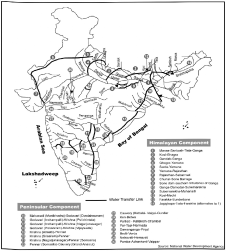
At the request of the Government of India, a UNO team prepared a project report on the Ganga-Kaveri Link Canal (Fig. 3.11). The main objectives of the project are to safeguard against the recurring floods in the Ganga Basin and to assure more water to the comparatively less rainfall receiving areas of central India. Under this project, the Ganga is to be linked with Kaveri by a man-made canal; 2636 km or 1650 miles long. This canal was proposed not only to provide drinking water to its command area, but also to provide water for irrigation and sanitation. In addition to these, the canal is supposed to help in the generation of hydel-power, navigation, flood control, tourism promotion, and recreation. The Ganga-Kaveri Link Canal is thus, a multi-purpose project of immense size. If completed, the country will no longer have to depend so much on monsoon, the vagaries of which are well known.
The scheme proposes to draw 1700 cumecs (60,000 cusecs) of water from the Ganga, constructing a barrage near Patna, and lift its water by large pumps to a point near the boundary of the basins of Ganga and the Narmada from where it will be possible to distribute the water by

Fig. 3.11 Inter Basin Water Transfer
gravity via dug-up canals or through existing rivers to the west or south. The flood waters ot the Narmada (flowing into the Arabian Sea) and the Godavari (flowing into the Bay ot Bengal) could also be used profitably by a separate water grid. Water for the inter basin transfer would be derived from the Ganga only during the four months of the rainy season (July to October) when the flow exceeds on an average by 2850 cumecs (100,000 cusecs).
The length of the Ganga-Kaveri Link Canal will be between 2400—3200 km, depending upon the actual alignment finally chosen, with smaller secondary branches connecting areas chronically prone to droughts. It is also proposed to supply the Ganga water to Bihar, Uttar Pradesh, Jharkhand, Chhattisgarh, Madhya Pradesh, and Rajasthan by pumping additional water during the lean water season. Similarly, 1410 cumecs (50,000 cusecs) of water pumped for 150 days or more, depending upon the surplus waters in the Ganga, would be diverted during the high flow period only, and would be transferred outside the basin to meet partially the water demand of the chronically drought prone areas of Rajasthan, Gujarat, Madhya Pradesh, Chhattisgarh, Maharashtra, Andhra Pradesh, Karnataka, and Tamil Nadu.
A site near Patna having an elevation of about 46 metres above sea level will be the starting point which would collect the surplus water from the Ganga. From here, the water would be pumped into a series of reservoirs between the watersheds of the Narmada and Son, involving a pumping lift of 335 to 400 m. From this elevation (Bagri Reservoir on the Narmada 423 m above sea level), a lined aquaduct will convey the water to the south utilising the natural water resources of the Wainganga, Pranhila, and Godavari, and crossing the Krishna and the Penner to Kaveri, upstream of the Upper Anicut.
Storage would be provided enroute, especially on the ridge regions to conserve the water for the dry season. These storages would be located inside valleys, which do not have sufficient catchment area of their own to provide adequate run-off which would be utilised during the dry season. On the way, water would also be released into the basins of the Narmada and the Tapi rivers which flows westward into the Arabian Sea, and the Godavari, the Krishna, the Penner, the Kaveri which flow eastward into the Bay of Bengal. From the selected points on the Son River itself, water pumped separately for the basin will be diverted to the drought prone areas in the Ganga basin.
The project involves huge expenditure, massive survey operations and strong administrative decisions. Since it will take a decade or more to complete the project which has several administrative and socio-ecological constraints, the government has not yet taken any decision to execute the project.
