
Evolution of the Himalayan Rivers
The geologists and geomorphologists are not unanimous about the origin of the Himalayan rivers. The Himalayan rivers have a long geological history. The major rivers of the Himalayas like Indus, Brahmaputra, Satluj, Ganga (Alaknanda and Bhagirathi), Gandak, Kali, Kosi, Tista, Manas, etc. originate on the southern slopes of the Tibetan Highlands. Rivers like Indus, Satluj and Brahmaputra first flowed parallel to the main axis of the moutain in longitudinal troughs, then Lhey take sudden bends towards the south, carving out deep gorges across the mountain ranges to reach the northern plains of India. Such deep gorges created by the Indus, Satluj, Alaknanda, Satju (Kali), Gandak, Kosi, Tista and Brahmaputra suggest that they arc older than the Himalayan mountains, and are antecedent in character.
E. H. Pascoe (1919) and G.E. Pilgrim (1919) attempted to give a tangible explanation to the problem of the Himalayan drainage. According to them, the Tibetan Plateau was drained to the west by the mighty Tsangpo-Indus-Oxus combine with the Tibetan river merging into Oxus Lake before the upheaval of the Himalayas (Fig. 3.5). Similarly, another big river called the Indo Brahma River (Pascoe, 1919) or the Shiwalik River (Pilgrim, 1919) traversed the entire longitudinal extent of the Himalaya from Assam to Punjab from north-east to empty into the Gulf of Sindh, near lower Punjab, during the Miocene Period (Fig. 3.5). The former (Tsangpo-Indus-Oxus) was disrupted by the headward erosion of its left hand tributaries, i.e. the Proto-Sind, the Proto-Satluj, the Proto- Brahmaputra, and later was captured by the present lower Irradwady-Chindwin, the lower Brahmaputra, the lower Satluj, and the lower Indus which are the probable remnants of the Shiwalik River.
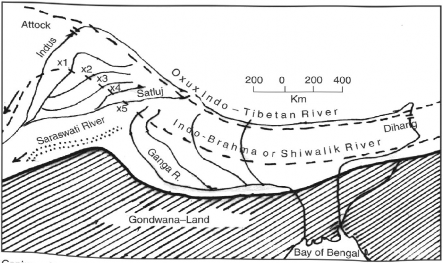
captures<nfT'betan River lndus at Attack and Brahmaputra at Dihang XrX5; successive Indo-Brahma or Shiwalik Rivers by the rivers of Punjab.
Fig. 3.5 Evolution of Himalayan Drainage
Later the mighty Shiwalik river was dismembered into three main systems: (i) the Indus and its tributaries in the western part, (ii) the Ganga and its Himalayan tributaries in the central part, and (iii) the Brahmaputra in Assam and its Himalayan tributaries in the eastern part (Fig. 3.5). The dismemberment is attributed to the Pleistocene upheaval in the Western Himalayas including the uplift of the Potwar Plateau (the Delhi Ridge) which acted as a water divide between the Indus and the Ganga systems. Similarly, the down thrusting of the Maida-Gap area between Rajmahal Hills and the Meghalaya Plateau during the mid-Pleistocence period (about 5 lakh years ago) caused the Ganga and the Brahmaputra systems to flow towards the Bay of Bengal. These developments brought a reversal in the direction of flow in the middle section of the severed stream, i.e. the Ganga of today, resulting in its taking a southerly course and eventually annexing the Yamuna and its tributaries. Earlier, the Yamuna had a south-westerly course and was a tributary of the Indus. This entire event was completed by the late Pleistocene period leading to the evolution of the present drainage systems of northern India.
Pascoe’s and Pilgrim’s concepts about the origin of the Himalayan drainage systems have been criticised on the following grounds:
(i) It is not necessary to postulate a stream of the size of Shiwalik River flowing all along the longitudinal extent of the Himalayas to explain the occurrence of the Shiwalik alluvial deposits and the boulder beds. They might represent a succession of alluvial fans deposited by rivers descending from the Himalayas, which have coalesced over time. Leading geologists, M.S. Krishnan and N.K.N. lyangar (1940) found it difficult to accept the existence of such a mighty river on geological as well as physiographic grounds.
(ii) The evidence furnished by the depositional history of the Ganga Delta does not fit well with the theory. In fact, the alluvium should have been laid down over a much longer period of time than that suggested in the concept.
(iii) The evidence of the Tipam sandstones of Assam, which were deposited in an estuary situated too close to the source of the Indo-Brahma River, also cast doubts over the acceptance of the theory.
Professor Enayat Ahmad (1965-71) has given his own interpretation of evolution of the Himalayan drainage. He opined that the Tethys remained as a basin of sedimentation from the Cambrian to the Eocene Periods, but the major portion of the Himalayan region was occupied by Gondwana I^andmass. During the Himalayan upheaval in the Oligocene period, part of the Tethysian geosyncline and probably, part of the Gondwana Land, were uplifted. Most probably, this marked the initiation of the Himalayan drainage. The Tethys Sea was raised into a landmass with a median mass of the high Tibetan Plateau in the centre and the two bordering ranges namely, the Kun-Lun in the north and the Himadari in the south. The drainage started from the southern edge of the median mass and flowed south towards the foredeep. As the formation of east-west ranges created east-west valleys, the rivers partly flowed along these valleys. This is indicated by the upper course of several rivers such as the Indus, the Shyok, the Satluj, the Ganga, the Brahmaputra, the Arun (Kosi), etc. Since the whole of the Tethys was not fully raised to become land surface, there existed patches of sea along the margins and drainage lines were not fully defined.
The second Himalayan upheaval during the mid-Miocene period increased the altitude of the medium mass and the bordering ranges. The remnant sea was raised to form the landmass. The rise in land resulted in greater and more invigorated drainage. Alongwith these changes, the region to the south of the first Himalayan range was raised as the Lesser Himalayan range. Earlier, streams on the southern margin of the Tibetan Plateau cut down deep valleys to maintain their courses. Along the southern slopes of the Lesser Himalayas, a number of consequent streams also merged which drained into the southern foredeep.
The third Himalayan upheaval during the Pleistocene perioid resulted into the folding of the Shiwalik foredeep into hill ranges. Also, the height of earlier ranges and the Tibetan Plateau were raised. The rise in the Tibetan Plateau blocked the streams that had gone northward into the Tibetan Sea. These streams were diverted east and west, which probably led to the formation of the Trans-Himalayan master stream. This master stream was broken into two (the Proto-Indus and the ProtoBrahmaputra) by the formation of the Kailash Range. The uplift of the Shiwalik range gave rise to the last set of consequents, originating on the crest of the range, into older streams.