
VULCANICITY
A volcano is an opening in the crust of the earth, connected by a conduit to an underlying magma chamber, from which molten lava, volcanic gases, steam, and pyroclastic materials are ejected. It is usually in the form of a peak which may be cone shaped or dome-shaped depending on the type of volcano and type of material ejected. The main causes of volcanic eruptions are associated with sea-floor spreading, plate-tectonics and mountain building processes.
At present, the only active volcanoes in India are at the Barren and Narcondom Islands (Andaman group of Islands), but geographical evidence is available for vulcanicity in the past. Prof. ILL. Clubber (1945) has identified six areas of vulcanicity in the country which are given as follows:
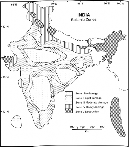
Fig. 2.25 India—Seismic Zones
1. The Dharwar Vulcanicity: Traces of basalt deposits are found in the form of D alma Trap in Jharkhand.
2. Cuddapah Vulcanicity: This occupies Cuddapah, Bijapur and Gwalior areas.
3. Vindhyan Vulcanicity: Its evidences are found in the Malani (Jodhpur) and Kirana (Punjan) Hills in Rajasthan.
4. Palaeozoic Vulcanicity: During this phase, volcanic eruptions were noticed in Kashmir and Himachal Pradesh. Traces of volcanic deposits have been found in Pir Panjal Range, Dalhousie (II.P.), Bhuwali, Bhimtal, and Saugaon (Kumaun-Uttarakhand).
5. Mesozoic Vulcanicity: During this period, volcanic eruption took place in Rajmahal Hills (Jharkhand) and Abor Hills of Arunachal Pradesh.
6. The Cretaceous Vulcanicity: During this period, enormous quantity of basalt upwelled through fissure eruptions over the north-western part of the Peninsula, forming the Deccan Trap.
Geologists opine that apart from the Barren Islands, volcanic activity is going on beneath the Himalayan crust due to the subduction and melting of the northern margin of the Indian Plate.
REFERENCES
Ahmed, E. Coastal Geomorphology of India. New Delhi: Orient Longman, 1972.
Blandford, W.T. “Physical Geography of the Indian Desert.” Journal of the Asiatic Society of Bengal, Calcutta (1876).
Burrard, S.G. “Origin of the Indo-Gangetic Trough—Commonly called Himalayan Foredeep.” Proceedings of the Royal Society, No. 91A, London (1915) : 220-238.
Chatterjee, S.P. “The National Atlas: Physical Plates.” National Atlas of India, Govt, oflndia, Calcutta (1974).
Deshpande, C.D. India-A Regional Interpretation. New Delhi; Indian Council of Social Science Research and National Book Centre, 1992. Gansser, A. Geology of Himalayas. New York: Interscience Publishers, John Wiley, 1964.
Ghose, B. et al. “Geomorphology of the Rajasthan Desert-Desertification and its Control.” Council of Agricultural Research, New Delhi (1977): 69—76. Holland, TH., Sir. Imperial Gazetteer of India, Vol. I, Govt, oflndia, Calcutta (1907).
Krishnan, M.S. Geology of India and Burma, Delhi: CBS Publishers, 1968.
Law, B.C. “Mountains and Rivers of India.” Geographical Review oflndia, Calcutta, (1968).
Spate, O.H.K. and Learmonth, A.T.N.India and Pakistan: A General and. Regional Geography. 3 rd rev. ed. London: Methuen & Co. Ltd., 1967. Wadia, D.N. The Role of Himalayan Mountains in the Physiography of Asia. Bose Research Institute, Vol. 30, Calcutta (1967).
Wadia, D.N. Geology oflndia. New Delhi: Tata McGraw-Hill Pub. Co. Ltd., 1967.