
♤ It was one of the subjects in the India-Pakistan composite dialogue that resumed under
Atal Bihari Vajpayee’s government in 2004.
♤ Six rounds of talks have taken place, the two sides have conducted a joint survey of the creek and exchanged maps showing their respective positions.
♤ The issue remains unresolved.
♤ Map3.3 Sir Creek
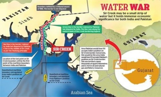
Image Source: http://media2.intoday.in/indiatoday/images/stories//2012december/sircreek02_small_121612120133.jp g
1.5.1. India’s Claims v Pakistan’s Claims

♤ The Provisions of two contradictory paragraphs in the 1914 Verdict of the Bombay Government, make India and Pakistan contenders on the same issue.
♤ Paragraph 9 of this verdict states that the boundary between Kutch and Sindh lies ‘to the east of the Creek,’ (Green Line) which effectively implied that the creek belonged to Sindh and, therefore, to Pakistan.
♤ On the other hand, Paragraph 10 states that since Sir Creek is navigable most of the year. According to international law and the Thalweg principle, a boundary can only be fixed in the middle of the navigable channel, which meant that it has be divided between Sindh and Kutch, and thereby India and Pakistan. This is the basis of India’s claim (red line) which is also bolstered by a map dating back to 1925.